IMAGES TAKEN NEAR TO
Abingdon Road, ABINGDON, OX14 4HP
Introduction
This page details the photographs taken nearby to Abingdon Road, OX14 4HP by members of the Geograph project.
The Geograph project started in 2005 with the aim of publishing, organising and preserving representative images for every square kilometre of Great Britain, Ireland and the Isle of Man.

There are currently over 7.5m images from over14,400 individuals and you can help contribute to the project by visiting https://www.geograph.org.uk
Image Map (Loading...)


Getting Data...Please wait
Leaflet Map data © OpenStreetMap
Images are licensed for reuse under creativecommons.org/licenses/by-sa/2.0
Notes
- Clicking on the map will re-center to the selected point.
- The higher the marker number, the further away the image location is from the centre of the postcode.
Image Listing (21 Images Found)
Images are licensed for reuse under creativecommons.org/licenses/by-sa/2.0
Image
Details
Distance
1

Terrace of houses on Abingdon Road, Sutton Wick
Image: © David Howard
Taken: 18 Feb 2019
0.06 miles
2
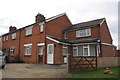
#85 Abingdon Road
In 1973 the Ordnance Survey cut a benchmark on the side of the house but the mark has been lost to extensions on this face
Image: © Roger Templeman
Taken: 6 Feb 2013
0.11 miles
3
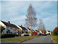
Hilliat Fields, Drayton
Much of Drayton village west of the B4017 looks a bit like this.
Image: © Des Blenkinsopp
Taken: 24 Oct 2011
0.18 miles
4
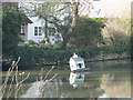
Pond with crooked duck-house in Drayton
Image: © Sarah Charlesworth
Taken: 19 Feb 2010
0.19 miles
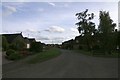
5
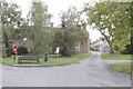
Lane to the right
Lane leading off Sutton Wick lane leading to further houses
Image: © Bill Nicholls
Taken: 12 Oct 2017
0.19 miles
6
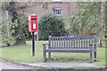
Bench by the postbox
Memorial bench by Sutton Wick lane beside an ER postbox
Image: © Bill Nicholls
Taken: 12 Oct 2017
0.20 miles
7
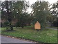
Memorial on the green
Memorial for the Sutton Wick air crash on the green near where it happened
https://en.wikipedia.org/wiki/Sutton_Wick_air_crash
Image: © Bill Nicholls
Taken: 12 Oct 2017
0.20 miles
8
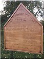
Now Amongst the Stars
The Sutton Wick air Crash memorial https://en.wikipedia.org/wiki/Sutton_Wick_air_crash
Image: © Bill Nicholls
Taken: 12 Oct 2017
0.20 miles
9
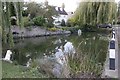
Pond at Sutton Wick
No doubt the village duck pond
Image: © Bill Nicholls
Taken: 12 Oct 2017
0.20 miles
10
Sutton Wick lane
The site of the air crash that took place on the 5th March 1957
Image: © Bill Nicholls
Taken: 12 Oct 2017
0.21 miles