IMAGES TAKEN NEAR TO
Drayton Road, ABINGDON, OX14 4EU
Introduction
This page details the photographs taken nearby to Drayton Road, OX14 4EU by members of the Geograph project.
The Geograph project started in 2005 with the aim of publishing, organising and preserving representative images for every square kilometre of Great Britain, Ireland and the Isle of Man.

There are currently over 7.5m images from over14,400 individuals and you can help contribute to the project by visiting https://www.geograph.org.uk
Image Map (Loading...)


Getting Data...Please wait
Leaflet Map data © OpenStreetMap
Images are licensed for reuse under creativecommons.org/licenses/by-sa/2.0
Notes
- Clicking on the map will re-center to the selected point.
- The higher the marker number, the further away the image location is from the centre of the postcode.
Image Listing (4 Images Found)
Images are licensed for reuse under creativecommons.org/licenses/by-sa/2.0
Image
Details
Distance
2

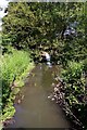
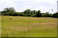
Milton Road south of Brook Farm
The road crosses a field drain here with the left hand parapet of the culvert covered with brambles
Image: © Roger Templeman
Taken: 24 Jan 2013
0.21 miles
3
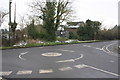
Mini roundabout at High Street/Sutton Road junction
A pumping station can be seen on the far side of the junction. In 1973 the Ordnance Survey levelled a rivet benchmark on the concrete base of the pumping station's left hand entrance gatepost, see http://www.bench-marks.org.uk/bm80819
Image: © Roger Templeman
Taken: 24 Jan 2013
0.24 miles