IMAGES TAKEN NEAR TO
Bradstocks Way, ABINGDON, OX14 4DA
Introduction
This page details the photographs taken nearby to Bradstocks Way, OX14 4DA by members of the Geograph project.
The Geograph project started in 2005 with the aim of publishing, organising and preserving representative images for every square kilometre of Great Britain, Ireland and the Isle of Man.

There are currently over 7.5m images from over14,400 individuals and you can help contribute to the project by visiting https://www.geograph.org.uk
Image Map
Images are licensed for reuse under creativecommons.org/licenses/by-sa/2.0
Notes
- Clicking on the map will re-center to the selected point.
- The higher the marker number, the further away the image location is from the centre of the postcode.
Image Listing (22 Images Found)
Images are licensed for reuse under creativecommons.org/licenses/by-sa/2.0
Image
Details
Distance
1

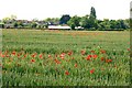
Ox-eye daisies in the meadow
Underneath this field are Romano-British, Iron Age and Saxon settlement remains. This Scheduled Ancient Monument is being managed by the Countryside Stewardship Scheme as a grass and wildflower hay meadow to avoid plough damage.
Image: © Steve Daniels
Taken: 10 Jun 2009
0.08 miles
2
Junction of Bradstocks Way and Harwell Road
In the background the parish's best known landmark - Didcot Power Station's cooling towers
Image: © Roger Templeman
Taken: 1 Sep 2010
0.09 miles
4

White Clover in the meadow
Underneath this field are Romano-British, Iron Age and Saxon settlement remains. This Scheduled Ancient Monument is being managed by the Countryside Stewardship Scheme as a grass and wildflower hay meadow to avoid plough damage.
Image: © Steve Daniels
Taken: 10 Jun 2009
0.10 miles
5
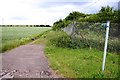
Bridleway to Didcot by Sutton Courtenay
Image: © Steve Daniels
Taken: 10 Jun 2009
0.12 miles
6

Red Clover in the meadow
Underneath this field are Romano-British, Iron Age and Saxon settlement remains. This Scheduled Ancient Monument is being managed by the Countryside Stewardship Scheme as a grass and wildflower hay meadow to avoid plough damage.
Image: © Steve Daniels
Taken: 10 Jun 2009
0.14 miles
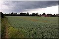
7
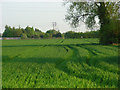
Farmland, Sutton Courtenay
A figure can be seen on the bridleway that runs along the power station perimeter.
Image: © Andrew Smith
Taken: 7 May 2008
0.16 miles