IMAGES TAKEN NEAR TO
Eason Drive, ABINGDON, OX14 3YD
Introduction
This page details the photographs taken nearby to Eason Drive, OX14 3YD by members of the Geograph project.
The Geograph project started in 2005 with the aim of publishing, organising and preserving representative images for every square kilometre of Great Britain, Ireland and the Isle of Man.

There are currently over 7.5m images from over14,400 individuals and you can help contribute to the project by visiting https://www.geograph.org.uk
Image Map (Loading...)


Getting Data...Please wait
Leaflet Map data © OpenStreetMap
Images are licensed for reuse under creativecommons.org/licenses/by-sa/2.0
Notes
- Clicking on the map will re-center to the selected point.
- The higher the marker number, the further away the image location is from the centre of the postcode.
Image Listing (5 Images Found)
Images are licensed for reuse under creativecommons.org/licenses/by-sa/2.0
Image
Details
Distance
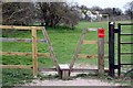
1
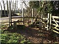
Stiles near Barrow Hills, Abingdon
On the path connecting Barrow Hills with SE Abingdon, at the junction with the road to Wick Hall
Image: © Chris Eilbeck
Taken: 21 Jan 2006
0.09 miles
3
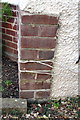
Benchmark on 'Woodgrange', Radley Road
Ordnance Survey cut mark benchmark described on the Bench Mark Database at http://www.bench-marks.org.uk/bm23340
Image: © Roger Templeman
Taken: 3 Oct 2011
0.22 miles