IMAGES TAKEN NEAR TO
Old Station Yard, ABINGDON, OX14 3LQ
Introduction
This page details the photographs taken nearby to Old Station Yard, OX14 3LQ by members of the Geograph project.
The Geograph project started in 2005 with the aim of publishing, organising and preserving representative images for every square kilometre of Great Britain, Ireland and the Isle of Man.

There are currently over 7.5m images from over14,400 individuals and you can help contribute to the project by visiting https://www.geograph.org.uk
Image Map (Loading...)


Getting Data...Please wait
Leaflet Map data © OpenStreetMap
Images are licensed for reuse under creativecommons.org/licenses/by-sa/2.0
Notes
- Clicking on the map will re-center to the selected point.
- The higher the marker number, the further away the image location is from the centre of the postcode.
Image Listing (499 Images Found)
Images are licensed for reuse under creativecommons.org/licenses/by-sa/2.0
Image
Details
Distance
1
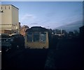
Excursion Train at Abingdon Station
Diesel Multiple-Unit train L470 on a Branch Lines Tour at Abingdon Station. The branch from Radley to Abingdon was closed to passengers in September, 1963 and to goods in 1984 with the track being subsequently lifted. This site is now occupied by housing and called "Old Station Yard".
More information on the station, including photographs, can be found at http://www.disused-stations.org.uk/a/abingdon/index.shtml. There is a website http://www.abingdonbranch.co.uk/ devoted to this branch line as well.
Image: © David Hillas
Taken: 10 Nov 1973
0.01 miles
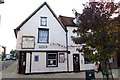
3
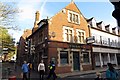
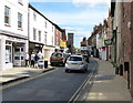
The Harp on Stert Street
The Harp was formerly the Plough, a former Morrells pub.
Image: © Steve Daniels
Taken: 23 Oct 2013
0.02 miles
4
The Harp on Stert Street
The Harp was formerly the Plough, a former Morrells pub.
Image: © Steve Daniels
Taken: 23 Oct 2013
0.02 miles
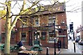
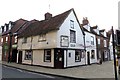
5
The Al-zaib on Stert Street
The Al-zaib was formerly the Beehive pub.
Image: © Steve Daniels
Taken: 23 Oct 2013
0.04 miles
6
The Al-zaib on Stert Street
The Al-zaib was formerly the Beehive pub.
Image: © Steve Daniels
Taken: 23 Oct 2013
0.04 miles
8
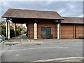
Abingdon railway station (site), Oxfordshire
Opened in 1856 by the Abingdon Railway, later part of the Great Western Railway, this was the terminus of a short branch which left the Paddington-Oxford line south of Radley. The station closed to passengers in 1963 and completely in 1984.
View east from near the buffers along the single passenger platform, which would probably have run straight through the grey doors. The site is now mostly a supermarket, but Abbey Close in the foreground cuts across the site between the platform and the site of the station building (behind the camera position). No trace remains.
Image: © Nigel Thompson
Taken: 26 May 2022
0.04 miles
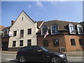
10
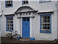
Abingdon - The Knowle
Historic and Georgian house in Stert Street, central Abingdon.
www.abingdon.gov.uk
Image: © Colin Smith
Taken: 26 Aug 2012
0.05 miles