IMAGES TAKEN NEAR TO
Bury Street, ABINGDON, OX14 3LL
Introduction
This page details the photographs taken nearby to Bury Street, OX14 3LL by members of the Geograph project.
The Geograph project started in 2005 with the aim of publishing, organising and preserving representative images for every square kilometre of Great Britain, Ireland and the Isle of Man.

There are currently over 7.5m images from over14,400 individuals and you can help contribute to the project by visiting https://www.geograph.org.uk
Image Map (Loading...)


Getting Data...Please wait
Leaflet Map data © OpenStreetMap
Images are licensed for reuse under creativecommons.org/licenses/by-sa/2.0
Notes
- Clicking on the map will re-center to the selected point.
- The higher the marker number, the further away the image location is from the centre of the postcode.
Image Listing (780 Images Found)
Images are licensed for reuse under creativecommons.org/licenses/by-sa/2.0
Image
Details
Distance
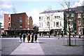
2
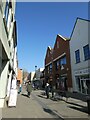
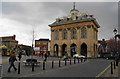
Market place, Abingdon
Historic core of the former county town of Abingdon.
www.abingdon.gov.uk
Image: © Colin Smith
Taken: 26 Aug 2012
0.01 miles
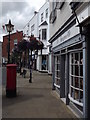
7
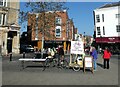
Looking across Stert Street towards Java & Co
Image: © Basher Eyre
Taken: 29 Oct 2013
0.02 miles
9

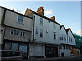
Couple of GPs
Couple of Lambretta GPs in the market square at Abingdon.
Image: © Bill Nicholls
Taken: 22 Jun 2014
0.03 miles
10
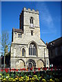
County Hall, Abingdon
The county involved was Berkshire even though this is now well into Oxfordshire, since the 1974 changes.
Image: © Bill Boaden
Taken: 7 Apr 2010
0.03 miles