IMAGES TAKEN NEAR TO
Burgess Close, ABINGDON, OX14 3JT
Introduction
This page details the photographs taken nearby to Burgess Close, OX14 3JT by members of the Geograph project.
The Geograph project started in 2005 with the aim of publishing, organising and preserving representative images for every square kilometre of Great Britain, Ireland and the Isle of Man.

There are currently over 7.5m images from over14,400 individuals and you can help contribute to the project by visiting https://www.geograph.org.uk
Image Map
Images are licensed for reuse under creativecommons.org/licenses/by-sa/2.0
Notes
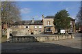
- Clicking on the map will re-center to the selected point.
- The higher the marker number, the further away the image location is from the centre of the postcode.
Image Listing (561 Images Found)
Images are licensed for reuse under creativecommons.org/licenses/by-sa/2.0
Image
Details
Distance
1
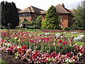
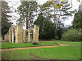
Abingdon - Abbey Gardens
Formal gardens within the bounds of the former Abingdon Abbey which suffered in Henry VIII's Dissolution of the Monasteries.
www.abingdon.gov.uk
Image: © Colin Smith
Taken: 26 Aug 2012
0.05 miles
2
Abbey Ruins, Abingdon
This is Abingdon's folly - they were built as ruins. They are within the site of the actual Abbey church.
Image: © Claire Ward
Taken: 31 May 2005
0.06 miles
3
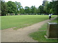
Abbey Grounds, Abingdon
Looking across the site of Abingdon Abbey, on the very edge of the grid square. Beyond the fenced off area work is being carried out in the old ornamental lake (where old army weapons have been found) to restore the Victorian look of the gardens.
Image: © Claire Ward
Taken: 31 May 2005
0.06 miles
4
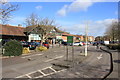
Waitrose Abingdon
This supermarket is on Abbey Close which is a small road leading off Vineyard.
Image: © Nigel Mykura
Taken: 1 Mar 2017
0.06 miles
5
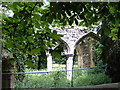
Trendrell's Folly, Abbey Gardens
A reconstruction of two arcades from St. Helen's church, Abingdon.
Image: © Jonathan Thacker
Taken: 1 Dec 2015
0.06 miles
6
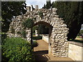
Abingdon Abbey - Relict Gateway
Old stone gateway from the dissolved abbey, in Abbey Gardens.
www.abingdon.gov.uk
Image: © Colin Smith
Taken: 26 Aug 2012
0.07 miles
7
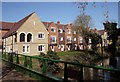
New Housing by the Mill Stream
A lot of new building in this part of Abingdon. These apartments look out over the Abbey Mill Stream near the ruins of Abingdon Abbey.
It looks like the architects were having a little abbey moment themselves when they sketched out this fancy arched balcony.
Image: © Des Blenkinsopp
Taken: 23 Mar 2011
0.07 miles
8
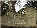
Medieval fragments
Possibly, but by no means certainly, from the former Abbey Church.
Image: © Jonathan Thacker
Taken: 1 Dec 2015
0.07 miles
9
Abingdon Council Offices
Does not look as posh as the White Horse District council offices but certainly look better.
Image: © Bill Nicholls
Taken: 20 Mar 2011
0.08 miles
10
Abingdon railway station (site), Oxfordshire
Opened in 1856 by the Abingdon Railway, later part of the Great Western Railway, this was the terminus of a short branch which left the Paddington-Oxford line south of Radley. The station closed to passengers in 1963 and completely in 1984.
View west towards the buffers. This viewpoint would have been just beyond the end of the single passenger platform, which would have run straight ahead. A goods yard was to the left of the image. The site is mostly a supermarket, but Abbey Close cuts across the site between the platform and the site of the station building. No trace remains.
Image: © Nigel Thompson
Taken: 26 May 2022
0.08 miles