IMAGES TAKEN NEAR TO
Cross Way, OX14 3FX
Introduction
This page details the photographs taken nearby to Cross Way, OX14 3FX by members of the Geograph project.
The Geograph project started in 2005 with the aim of publishing, organising and preserving representative images for every square kilometre of Great Britain, Ireland and the Isle of Man.

There are currently over 7.5m images from over14,400 individuals and you can help contribute to the project by visiting https://www.geograph.org.uk
Image Map
Images are licensed for reuse under creativecommons.org/licenses/by-sa/2.0
Notes
- Clicking on the map will re-center to the selected point.
- The higher the marker number, the further away the image location is from the centre of the postcode.
Image Listing (9 Images Found)
Images are licensed for reuse under creativecommons.org/licenses/by-sa/2.0
Image
Details
Distance
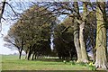
2
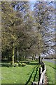
Evening Light near Radley College
This is the same place as Image at a different time of year with low winter sun making the trees glow.
This looks like it was the original entrance to the college, but now it's not even officially a footpath, although the dog walker's obviously using it.
Image: © Des Blenkinsopp
Taken: 15 Nov 2011
0.13 miles
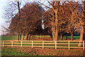
4

Footpath off White's Lane, Radley
Entrance to the footpath via a wooden bridge over the ditch.
Image: © David P Howard
Taken: 9 Apr 2010
0.17 miles
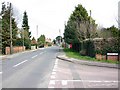
5
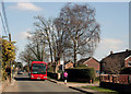
Bus and Jogger, Radley
Radley's Foxborough Road is fairly ordinary, but it has a bus into town every 15 minutes which makes it a lot different from the average village street round here.
Image: © Des Blenkinsopp
Taken: 23 Mar 2011
0.18 miles
7
Foxborough Road, Radley
View ENE at the junction with Badgers Copse.
Image: © David P Howard
Taken: 9 Apr 2010
0.21 miles
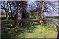
8
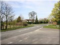
Staggered junction on Foxborough Road, Radley
View NNE. Thrupp Lane is to the right, and White's Lane to the left.
Image: © David P Howard
Taken: 9 Apr 2010
0.22 miles
9
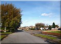
St James Rd, Radley
St James' Church is up the end of the road and to the left a bit.
I lived in a St James Rd when I was a kid.
Not this one though.
Image: © Des Blenkinsopp
Taken: 30 Oct 2012
0.24 miles