IMAGES TAKEN NEAR TO
Clifton Hampden, ABINGDON, OX14 3DD
Introduction
This page details the photographs taken nearby to OX14 3DD by members of the Geograph project.
The Geograph project started in 2005 with the aim of publishing, organising and preserving representative images for every square kilometre of Great Britain, Ireland and the Isle of Man.

There are currently over 7.5m images from over14,400 individuals and you can help contribute to the project by visiting https://www.geograph.org.uk
Image Map (Loading...)


Getting Data...Please wait
Leaflet Map data © OpenStreetMap
Images are licensed for reuse under creativecommons.org/licenses/by-sa/2.0
Notes
- Clicking on the map will re-center to the selected point.
- The higher the marker number, the further away the image location is from the centre of the postcode.
Image Listing (11 Images Found)
Images are licensed for reuse under creativecommons.org/licenses/by-sa/2.0
Image
Details
Distance
1
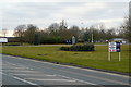
Culham Science Park
Formerly Royal Naval Air Station HMS Hornbill. After closure in 1956 it transferred to the UK Atomic Energy Authority in 19860 and is now Culham Science Centre. This is the entrance off the A415.
Image: © Graham Horn
Taken: 10 Mar 2010
0.05 miles
2
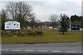
Culham science centre
Formerly Royal Naval Air Station HMS Hornbill. After closure in 1956 it transferred to the UK Atomic Energy Authority in 19860 and is now Culham Science Centre. This is the entrance off the A415.
Image: © Graham Horn
Taken: 10 Mar 2010
0.09 miles
3
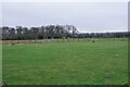
Paddock near Fullamoor Farm
Between the A415 and the River Thames.
Image: © Bill Boaden
Taken: 28 Dec 2020
0.11 miles
5
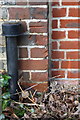
Benchmark on North Cottage
Ordnance Survey cut mark benchmark described on the Bench Mark Database at http://www.bench-marks.org.uk/bm24751
Image: © Roger Templeman
Taken: 22 Jan 2015
0.13 miles
6
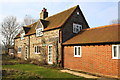
North Cottage, Fullamoor Farm
There is an OS benchmark Image on the corner of the original house at its junction with the new extension.
Image: © Roger Templeman
Taken: 22 Jan 2015
0.13 miles
7
Part of Fullamoor Farms
An entrance to an arable unit off Abingdon Road.
Image: © Bill Boaden
Taken: 28 Dec 2020
0.14 miles
8
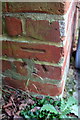
Benchmark on 'Stable House'
Ordnance Survey cut mark benchmark described on the Bench Mark Database at http://www.bench-marks.org.uk/bm24750
Image: © Roger Templeman
Taken: 22 Jan 2015
0.16 miles
9
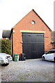
West face of Stable House barn conversion
There is an OS benchmark Image on the left hand side of the building at the near corner (at the end of the hedge)
Image: © Roger Templeman
Taken: 22 Jan 2015
0.16 miles
10
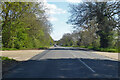
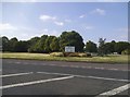
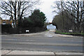
A415 Abingdon Road
Heading east away from Abingdon towards Clifton Hampden.
Image: © Robin Webster
Taken: 25 Apr 2021
0.17 miles