IMAGES TAKEN NEAR TO
Culham Science Centre, ABINGDON, OX14 3DB
Introduction
This page details the photographs taken nearby to Culham Science Centre, OX14 3DB by members of the Geograph project.
The Geograph project started in 2005 with the aim of publishing, organising and preserving representative images for every square kilometre of Great Britain, Ireland and the Isle of Man.

There are currently over 7.5m images from over14,400 individuals and you can help contribute to the project by visiting https://www.geograph.org.uk
Image Map (Loading...)


Getting Data...Please wait
Leaflet Map data © OpenStreetMap
Images are licensed for reuse under creativecommons.org/licenses/by-sa/2.0
Notes
- Clicking on the map will re-center to the selected point.
- The higher the marker number, the further away the image location is from the centre of the postcode.
Image Listing (4 Images Found)
Images are licensed for reuse under creativecommons.org/licenses/by-sa/2.0
Image
Details
Distance
1
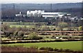
Culham Laboratory from Wittenham Clumps
Image: © Steve Daniels
Taken: 1 Apr 2009
0.12 miles
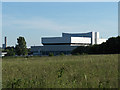
2

Culham Laboratory
Looking towards the main buildings from just outside the site on the perimeter road of the former airfield on which the Lab is built.
This is the UK's leading research site into fusion energy. http://www.ccfe.ac.uk/
Image: © Des Blenkinsopp
Taken: 3 Mar 2012
0.13 miles
3
Culham Science Centre
View from the edge of New Covert. A chimney and cooling tower at Didcot can also be seen. See http://www.controltowers.co.uk/C/Culham.htm for a picture of the site in its days as an airfield.
Image: © Andrew Smith
Taken: 3 Jun 2006
0.14 miles
4
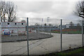
New development at Culham Science Centre
A new building is being erected, though the view is a little obscured by the perimeter fence.
Image: © Bill Boaden
Taken: 28 Dec 2020
0.25 miles