IMAGES TAKEN NEAR TO
Station Road, ABINGDON, OX14 3DA
Introduction
This page details the photographs taken nearby to Station Road, OX14 3DA by members of the Geograph project.
The Geograph project started in 2005 with the aim of publishing, organising and preserving representative images for every square kilometre of Great Britain, Ireland and the Isle of Man.

There are currently over 7.5m images from over14,400 individuals and you can help contribute to the project by visiting https://www.geograph.org.uk
Image Map
Images are licensed for reuse under creativecommons.org/licenses/by-sa/2.0
Notes
- Clicking on the map will re-center to the selected point.
- The higher the marker number, the further away the image location is from the centre of the postcode.
Image Listing (64 Images Found)
Images are licensed for reuse under creativecommons.org/licenses/by-sa/2.0
Image
Details
Distance
1
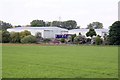
Science and Technology Centre
http://www.ccfe.ac.uk/
Image: © N Chadwick
Taken: 22 Feb 2014
0.05 miles
3
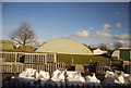
Old Hangar, Culham Airfield
One of the many old WW2 buildings on the former Culham Airfield. The old airfield site is now two sections. Firstly there is Culham Laboratory, a science facility visible in the distance beyond the fence, and secondly a business park now called Culham No.1 site which is largely made up of well preserved wartime sheds and hangars.
The site is summed up in this extract from South Oxfordshire District Council's Local Plan :-
"Number 1 Site, Culham was formerly owned by the Government and during the Second World War was also part of the Royal Naval Air Station. Most of the buildings were constructed as wartime works. From 1968 the buildings were used by the Natural Resources Institute and the Ministry of Agriculture Fisheries and Food for storage, distribution, workshops, offices and research. In 1996 the site was sold to a private company and a number of individual occupants began to use the site for a variety of uses.
The buildings are lawful but the uses taking place on the site in 2001, including the areas of hardstanding used for outside storage, remain vulnerable to enforcement action. The Council recognises that these buildings and some of the uses have a harmful impact on the openness of the Green Belt and wishes to see the site sensitively redeveloped. The buildings are dispersed throughout the site. They are generally unattractive due to their bulk, height and form, and the materials used in their construction."
A more or less mirror image of this building is about 200 metres west of here in the next square.
Image: © Des Blenkinsopp
Taken: 3 Mar 2012
0.07 miles
4

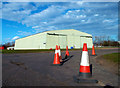
Old Hangar, Culham Airfield
One of the many old WW2 buildings on the former Culham Airfield. The old airfield site is now two sections. Firstly there is Culham Laboratory, a science facility, and secondly a business park now called Culham No.1 site which is largely made up of well preserved wartime sheds and hangars.
The site is summed up in this extract from South Oxfordshire District Council's Local Plan :-
"Number 1 Site, Culham was formerly owned by the Government and during the Second World War was also part of the Royal Naval Air Station. Most of the buildings were constructed as wartime works. From 1968 the buildings were used by the Natural Resources Institute and the Ministry of Agriculture Fisheries and Food for storage, distribution, workshops, offices and research. In 1996 the site was sold to a private company and a number of individual occupants began to use the site for a variety of uses.
The buildings are lawful but the uses taking place on the site in 2001, including the areas of hardstanding used for outside storage, remain vulnerable to enforcement action. The Council recognises that these buildings and some of the uses have a harmful impact on the openness of the Green Belt and wishes to see the site sensitively redeveloped. The buildings are dispersed throughout the site. They are generally unattractive due to their bulk, height and form, and the materials used in their construction."
A more or less mirror image of this building is about 200 metres east of here in the next square. Image
Image: © Des Blenkinsopp
Taken: 3 Mar 2012
0.08 miles
6
Benchmark on previous MOD gatehouse
Ordnance Survey cut mark benchmark described on the Bench Mark Database at http://www.bench-marks.org.uk/bm24755
Image: © Roger Templeman
Taken: 22 Jan 2015
0.09 miles
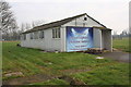
7
Unit 112 Culham No. 1 Site
There is an OS benchmark Image low down at the middle of the left hand face of the building which is currently occupied by Ideal Flooring
Image: © Roger Templeman
Taken: 22 Jan 2015
0.09 miles
8
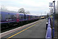
Culham station
This is the new up, Paddington bound, platform replacing the original one which was deemed too narrow. This is because non-stop trains pass through here at quite high speed. Indeed here is a north bound First Great Western class 165 3-car diesel multiple unit on a Paddington to Oxford semi-fast service, passing a southbound First Great Western service from, probably, Hereford or Worcester to London Paddington, operated with a High Speed Train. Neither is stopping.
Image: © Graham Horn
Taken: 10 Mar 2010
0.09 miles
9
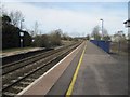
Looking towards Oxford
View along the railway in the Oxford direction, from here the next station is Radley though none of the original station buildings remain there.
Image: © Bill Nicholls
Taken: 28 Dec 2011
0.10 miles
10
Oxford Lighting & Electrical Solutions at Culham No. 1 Site
Image: © Roger Templeman
Taken: 22 Jan 2015
0.10 miles