IMAGES TAKEN NEAR TO
St. Andrews Close, ABINGDON, OX14 2NT
Introduction
This page details the photographs taken nearby to St. Andrews Close, OX14 2NT by members of the Geograph project.
The Geograph project started in 2005 with the aim of publishing, organising and preserving representative images for every square kilometre of Great Britain, Ireland and the Isle of Man.

There are currently over 7.5m images from over14,400 individuals and you can help contribute to the project by visiting https://www.geograph.org.uk
Image Map
Images are licensed for reuse under creativecommons.org/licenses/by-sa/2.0
Notes
- Clicking on the map will re-center to the selected point.
- The higher the marker number, the further away the image location is from the centre of the postcode.
Image Listing (3 Images Found)
Images are licensed for reuse under creativecommons.org/licenses/by-sa/2.0
Image
Details
Distance
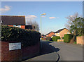
1
Elizabeth Avenue
No special reason for this pic. Just a sample image of this newish part of Abingdon on a nice afternoon.
Image: © Des Blenkinsopp
Taken: 23 Mar 2011
0.04 miles
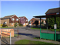
2
Yeld Hall Road
The architecture may be ordinary but the street names are far from it.
Yeld Hall, Amyce, Barfleur and Ethelhelm.
How many times do you see that lot on one notice.
Image: © Des Blenkinsopp
Taken: 23 Mar 2011
0.10 miles