IMAGES TAKEN NEAR TO
Lodge Hill, ABINGDON, OX14 2JB
Introduction
This page details the photographs taken nearby to Lodge Hill, OX14 2JB by members of the Geograph project.
The Geograph project started in 2005 with the aim of publishing, organising and preserving representative images for every square kilometre of Great Britain, Ireland and the Isle of Man.

There are currently over 7.5m images from over14,400 individuals and you can help contribute to the project by visiting https://www.geograph.org.uk
Image Map (Loading...)


Getting Data...Please wait
Leaflet Map data © OpenStreetMap
Images are licensed for reuse under creativecommons.org/licenses/by-sa/2.0
Notes
- Clicking on the map will re-center to the selected point.
- The higher the marker number, the further away the image location is from the centre of the postcode.
Image Listing (20 Images Found)
Images are licensed for reuse under creativecommons.org/licenses/by-sa/2.0
Image
Details
Distance
1
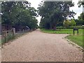
Oxford Green Belt Way
From Radley Park the Oxford Green Belt Way path nearing Oxford Road Lodge Hill
Image: © Shaun Ferguson
Taken: 14 Aug 2012
0.04 miles
2
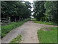
Footpath from Radley Park to Oxford Road, Lodge Hill
Photograph showing very nearly the same view as this geograph Image taken nearly eight years earlier. Driveway to Park House on the right, stables on the left, with Oxford Road junction straight ahead.
Image: © Jim Champion
Taken: 6 Aug 2020
0.04 miles
3
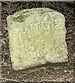
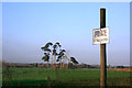
Old milestone at Lodge Hill alongside the A4183 road
Carved granite post by the A4183 (Oxford Road), in the parish of Radley (Vale of White Horse District). Located at Lodge Hill, hidden in the hedge on the east side of the road but accurately located on the OS maps. Erected by the Hinksey Road turnpike trust in the early 19th century.
Inscription reads:-
OXFORD
4
ABINGDON
2
It has a rivet and engraved benchmark on the top.
Grade II listed.
Image: © Jim Champion
Taken: 9 Apr 2024
0.09 miles
4

Lodge Hill Garage
This model spitfire is on, or over, the forecourt at Lodge Hill Garage just north of Abingdon.
According to this blog http://www.abingdonblog.co.uk/?p=3718 it is to commemorate the Air Transport Auxiliary.
Image: © Des Blenkinsopp
Taken: 15 Nov 2011
0.13 miles
5
End of the cycle route north out of Abingdon
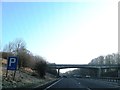
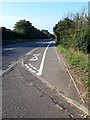
This cycle route runs alongside the A4183 (Oxford Road) heading north out of Abingdon over Lodge Hill. The separate cycle route ends here at the Lodge Hill interchange with the A34 dual carriageway (not recommended for cyclists). Oxford Road continues to the north, behind the photographer, as a B-road. This route and others in the area have recently had some much-needed maintenance - white lines have been repainted, trees and bushes cut back and encroaching verges returned to where they should be - scrape-marks from the work can be seen on the tarmac along the 'pedestrian' side of the path. This particular cycle route does not see heavy use by cyclists.
Image: © Jim Champion
Taken: 8 Aug 2020
0.13 miles
7
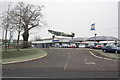
Lodge Hill Garage, Oxford Road
View of garage across the A4183 with replica Spitfire mounted on the roof as memorial to brave wartime women pilots
Image: © Roger Templeman
Taken: 16 Jan 2013
0.15 miles
9
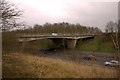
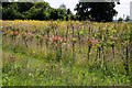
Oxford Road over the A34
Taken from a field just off Oxford Road (A4183).
Image: © Chris Drew
Taken: 7 Jan 2007
0.19 miles