IMAGES TAKEN NEAR TO
Oxford Road, ABINGDON, OX14 2DZ
Introduction
This page details the photographs taken nearby to Oxford Road, OX14 2DZ by members of the Geograph project.
The Geograph project started in 2005 with the aim of publishing, organising and preserving representative images for every square kilometre of Great Britain, Ireland and the Isle of Man.

There are currently over 7.5m images from over14,400 individuals and you can help contribute to the project by visiting https://www.geograph.org.uk
Image Map
Images are licensed for reuse under creativecommons.org/licenses/by-sa/2.0
Notes
- Clicking on the map will re-center to the selected point.
- The higher the marker number, the further away the image location is from the centre of the postcode.
Image Listing (59 Images Found)
Images are licensed for reuse under creativecommons.org/licenses/by-sa/2.0
Image
Details
Distance
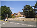
1
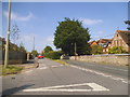
Abbott Road at the junction of Oxford Road
Image: © David Howard
Taken: 29 May 2016
0.04 miles
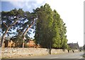
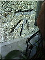
2
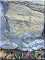
Old benchmark on wall of Convent, Oxford Road
Ordnance Survey cut mark benchmark described on the Bench Mark Database at http://www.bench-marks.org.uk/bm23889
Image: © Roger Templeman
Taken: 20 Oct 2010
0.05 miles
4
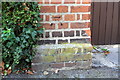
Benchmark on gatepost of #34 St Johns Road
Ordnance Survey cut mark benchmark described on the Bench Mark Database at http://www.bench-marks.org.uk/bm22122
Image: © Roger Templeman
Taken: 3 Oct 2011
0.05 miles
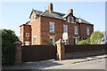
5
OLA Catholic School, Oxford Road
Our Lady of Abingdon School http://www.olab.org.uk/
Image: © David Howard
Taken: 29 May 2016
0.05 miles
6
OLA Catholic School, Oxford Road
http://www.olab.org.uk/
Image: © David Howard
Taken: 29 May 2016
0.06 miles
7
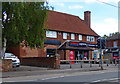
Tesco Express on Oxford Road, Abingdon
Image: © Mat Fascione
Taken: 15 Jun 2015
0.08 miles
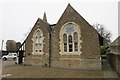
8
St Edmund?s school
The former St Edmund’s school now used as the church hall for Our Lady & St Edmund's church
Image: © Bill Nicholls
Taken: 10 Feb 2018
0.10 miles
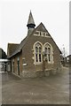
9
The old school
The former St Edmund’s school now used as the church hall for Our Lady & St Edmund’s church
Image: © Bill Nicholls
Taken: 10 Feb 2018
0.10 miles
10
Benchmark on #41 Boxhill Road
Ordnance Survey cut mark benchmark described on the Bench Mark Database at http://www.bench-marks.org.uk/bm23274
Image: © Roger Templeman
Taken: 17 Sep 2010
0.11 miles