IMAGES TAKEN NEAR TO
Langley Road, ABINGDON, OX14 1YB
Introduction
This page details the photographs taken nearby to Langley Road, OX14 1YB by members of the Geograph project.
The Geograph project started in 2005 with the aim of publishing, organising and preserving representative images for every square kilometre of Great Britain, Ireland and the Isle of Man.

There are currently over 7.5m images from over14,400 individuals and you can help contribute to the project by visiting https://www.geograph.org.uk
Image Map
Images are licensed for reuse under creativecommons.org/licenses/by-sa/2.0
Notes
- Clicking on the map will re-center to the selected point.
- The higher the marker number, the further away the image location is from the centre of the postcode.
Image Listing (8 Images Found)
Images are licensed for reuse under creativecommons.org/licenses/by-sa/2.0
Image
Details
Distance
1
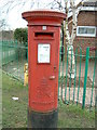
Post Box, Long Furlong, Abingdon, Oxfordshire
Post Box outside the Long Furlong Community Centre
Image: © Claire Ward
Taken: 28 Feb 2005
0.09 miles
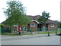
4
Long Furlong School
This school is on the edge of the grid square
Image: © Claire Ward
Taken: 28 May 2005
0.15 miles
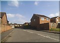
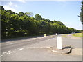
5
Hanson Road at the junction of Dunmore Road
Image: © David Howard
Taken: 29 May 2016
0.15 miles
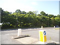
6
Dunmore Road at the junction on Hanson Road
Image: © David Howard
Taken: 29 May 2016
0.16 miles
7
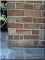
Benchmark on #103 South Avenue
Ordnance Survey cut mark benchmark described on the Bench Mark Database at http://www.bench-marks.org.uk/bm23436.
Image: © Roger Templeman
Taken: 17 Sep 2010
0.23 miles
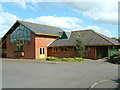
8
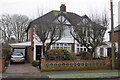
#103 and #105 South Avenue
There is an OS benchmark Image on the back corner of the left hand side house under its car port.
Image: © Roger Templeman
Taken: 16 Jan 2013
0.23 miles