IMAGES TAKEN NEAR TO
Bath Street, ABINGDON, OX14 1TT
Introduction
This page details the photographs taken nearby to Bath Street, OX14 1TT by members of the Geograph project.
The Geograph project started in 2005 with the aim of publishing, organising and preserving representative images for every square kilometre of Great Britain, Ireland and the Isle of Man.

There are currently over 7.5m images from over14,400 individuals and you can help contribute to the project by visiting https://www.geograph.org.uk
Image Map (Loading...)


Getting Data...Please wait
Leaflet Map data © OpenStreetMap
Images are licensed for reuse under creativecommons.org/licenses/by-sa/2.0
Notes
- Clicking on the map will re-center to the selected point.
- The higher the marker number, the further away the image location is from the centre of the postcode.
Image Listing (385 Images Found)
Images are licensed for reuse under creativecommons.org/licenses/by-sa/2.0
Image
Details
Distance
1
Benchmark on The Plough, Stert Street
Ordnance Survey cut mark benchmark described on the Bench Mark Database at http://www.bench-marks.org.uk/bm21934
Image: © Roger Templeman
Taken: 17 Sep 2010
0.05 miles
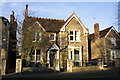
3
Withington Ct. Abingdon
Residential no through road just north of the town centre.
Image: © Des Blenkinsopp
Taken: 13 May 2013
0.06 miles
4
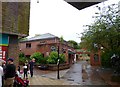
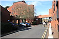
Bath Street/ Stratton Way crossroads from the bus station.
Image: © Roger Templeman
Taken: 1 Sep 2010
0.07 miles
5
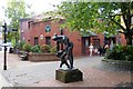
Abingdon Library
In The Charter pedestrian precinct. http://www.oxfordshire.gov.uk/cms/content/abingdon-library
Image: © Mike Faherty
Taken: 7 Jul 2012
0.07 miles
7
Benchmark on gatepost of Launton Lodge, Park Road
Ordnance Survey cut mark benchmark described on the Bench Mark Database at http://www.bench-marks.org.uk/bm22121
Image: © Roger Templeman
Taken: 17 Sep 2010
0.08 miles
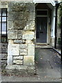
8
#23 Park Road
There is an OS benchmark Image on the gatepost to the left of the gate
Image: © Roger Templeman
Taken: 10 Dec 2011
0.08 miles
9
The Charter
The Charter in the centre of Abingdon. The building on the right is the multi storey car park
Image: © Nigel Mykura
Taken: 1 Mar 2017
0.08 miles
10
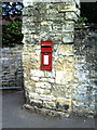
Benchmark on wall pier at junction of Bath Street and footpath
The Ordnance Survey cut mark benchmark is described on the Bench Mark Database at http://www.bench-marks.org.uk/bm23141
Image: © Roger Templeman
Taken: 17 Sep 2010
0.08 miles