IMAGES TAKEN NEAR TO
Hazel Close, ABINGDON, OX14 1TL
Introduction
This page details the photographs taken nearby to Hazel Close, OX14 1TL by members of the Geograph project.
The Geograph project started in 2005 with the aim of publishing, organising and preserving representative images for every square kilometre of Great Britain, Ireland and the Isle of Man.

There are currently over 7.5m images from over14,400 individuals and you can help contribute to the project by visiting https://www.geograph.org.uk
Image Map (Loading...)


Getting Data...Please wait
Leaflet Map data © OpenStreetMap
Images are licensed for reuse under creativecommons.org/licenses/by-sa/2.0
Notes
- Clicking on the map will re-center to the selected point.
- The higher the marker number, the further away the image location is from the centre of the postcode.
Image Listing (13 Images Found)
Images are licensed for reuse under creativecommons.org/licenses/by-sa/2.0
Image
Details
Distance
1
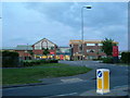
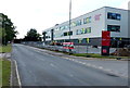
Abingdon College
The buildings in the photo form the new extension to the college
Image: © Claire Ward
Taken: 29 May 2005
0.03 miles
2
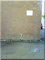
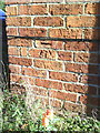
Building in Southern Electricity compound on Wootton Road with benchmark
The Ordnance Survey cut mark benchmark is described on the Bench Mark Database at http://www.bench-marks.org.uk/bm22886. A closeup of the benchmark is at Image
Image: © Roger Templeman
Taken: 20 Oct 2010
0.04 miles
3
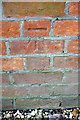
Benchmark on Southern Electricity depot, Wootton Road
Ordnance Survey cut mark benchmark described on the Bench Mark Database at http://www.bench-marks.org.uk/bm22886
Image: © Roger Templeman
Taken: 4 Mar 2013
0.04 miles
4
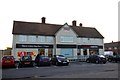
Tesco Express in Thornhill Walk
The shop is in the former Fitzharris Arms public house.
Image: © Steve Daniels
Taken: 6 May 2012
0.13 miles
5
Benchmark on #18 Borough Walk
Ordnance Survey cut mark benchmark described on the Bench Mark Database at http://www.bench-marks.org.uk/bm22884
Image: © Roger Templeman
Taken: 20 Oct 2010
0.13 miles

9
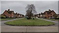
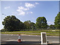
Green Space
Saint Mary's Green to the left and Saint Nicholas' Green to the right
Image: © Shaun Ferguson
Taken: 10 Jan 2022
0.22 miles