IMAGES TAKEN NEAR TO
Spring Road, ABINGDON, OX14 1AN
Introduction
This page details the photographs taken nearby to Spring Road, OX14 1AN by members of the Geograph project.
The Geograph project started in 2005 with the aim of publishing, organising and preserving representative images for every square kilometre of Great Britain, Ireland and the Isle of Man.

There are currently over 7.5m images from over14,400 individuals and you can help contribute to the project by visiting https://www.geograph.org.uk
Image Map (Loading...)


Getting Data...Please wait
Leaflet Map data © OpenStreetMap
Images are licensed for reuse under creativecommons.org/licenses/by-sa/2.0
Notes
- Clicking on the map will re-center to the selected point.
- The higher the marker number, the further away the image location is from the centre of the postcode.
Image Listing (156 Images Found)
Images are licensed for reuse under creativecommons.org/licenses/by-sa/2.0
Image
Details
Distance
1

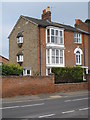
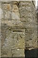
Benchmark on wall of #44A Spring Road
Ordnance Survey cut mark benchmark described on the Bench Mark Database at http://www.bench-marks.org.uk/bm22903
Image: © Roger Templeman
Taken: 2 Oct 2010
0.01 miles
2
Abingdon Cemetery Entrance
Situated in Spring road this is the entrance to the old cemetery
Image: © Claire Ward
Taken: 4 Jun 2005
0.02 miles
4
Entrance to the estate around Albert Park, Abingdon
Albert Park, Abingdon, was laid out as a result of the suppression of various medieval charities, and the trustees also laid out some quiet gated streets of Victorian dwellings to surround the park.
Image: © Christopher Hilton
Taken: 28 May 2017
0.04 miles
5
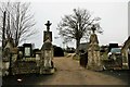
Cemetery gates
The cemetery gates for Abingdon Old Cemetery along Spring Road
Image: © Bill Nicholls
Taken: 10 Feb 2018
0.05 miles
6
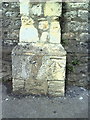
Abingdon Cemetery Benchmark
The cut mark on the wall beside the gatehouse at Abingdon Old Cemetery
Image: © Bill Nicholls
Taken: 10 Feb 2018
0.05 miles
7
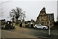
Cemetery gatehouse
Abingdon Old cemetery gatehouse
Image: © Bill Nicholls
Taken: 10 Feb 2018
0.06 miles
8
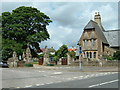
Benchmark on wall pier of Abingdon Cemetery Lodge
Ordnance Survey cut mark benchmark described at the Bench Mark Database at http://www.bench-marks.org.uk/bm22119
Image: © Roger Templeman
Taken: 2 Oct 2010
0.06 miles
9
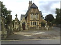
Cemetery Lodge on Spring Road
There is an OS benchmark Image on the front of the wall pier at the right hand end of the wall in front of the lodge
Image: © Roger Templeman
Taken: 2 Oct 2010
0.06 miles
10
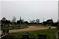
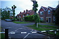
Cemetery road
The cemetery road leading to the east chapel with the west chapel over to the left at Abingdon Old Cemetery
Image: © Bill Nicholls
Taken: 10 Feb 2018
0.06 miles