IMAGES TAKEN NEAR TO
Pugsden Lane, ABINGDON, OX13 6RY
Introduction
This page details the photographs taken nearby to Pugsden Lane, OX13 6RY by members of the Geograph project.
The Geograph project started in 2005 with the aim of publishing, organising and preserving representative images for every square kilometre of Great Britain, Ireland and the Isle of Man.

There are currently over 7.5m images from over14,400 individuals and you can help contribute to the project by visiting https://www.geograph.org.uk
Image Map
Images are licensed for reuse under creativecommons.org/licenses/by-sa/2.0
Notes
- Clicking on the map will re-center to the selected point.
- The higher the marker number, the further away the image location is from the centre of the postcode.
Image Listing (75 Images Found)
Images are licensed for reuse under creativecommons.org/licenses/by-sa/2.0
Image
Details
Distance
1
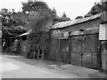
Old Sheds at Steventon
A former Coal Merchant's premises near to the site of the now vanished Steventon station.
There is another old truck in behind the corrugated panels. Neither have moved for years by the look.
In fact the whole place looked totally derelict until I was about to take a picture when a woman came out and opened up the middle doors to get something.
Image: © Des Blenkinsopp
Taken: 3 Aug 2011
0.04 miles
2
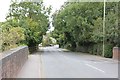
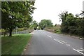
Into Steventon from the bridge
View in to Steventon along the High Street from the road bridge.
Image: © Bill Nicholls
Taken: 7 Sep 2011
0.05 miles
3

High Street in Steventon crosses the main line
Image: © Steve Daniels
Taken: 2 Sep 2009
0.05 miles
4
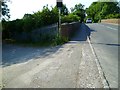
The Orange Way after Wiltshire (150)
This is the railway bridge on Steventon High Street.
Image: © Shazz
Taken: 7 Jul 2013
0.06 miles
5
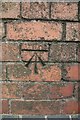
Steventon bridge benchmark
Close up of the benchmark on Steventon road bridge. Image
Image: © Bill Nicholls
Taken: 7 Sep 2011
0.06 miles
6
Into Steventon
View into Steventon towards the High Street with the road bridge centre photo.
Image: © Bill Nicholls
Taken: 7 Sep 2011
0.06 miles

8
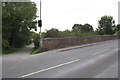
B4017 road bridge over Great Western Main Line
There is an Ordnance Survey cut mark benchmark, described on the Bench Mark Database at http://www.bench-marks.org.uk/bm22896 , on the parapet about 2ft from the near end.
Image: © Roger Templeman
Taken: 7 Sep 2011
0.06 miles
9
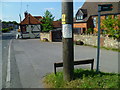
The Orange Way after Wiltshire (152)
The Way continues on Pugsden Lane which is the byway to the right here.
Image: © Shazz
Taken: 7 Jul 2013
0.06 miles
10
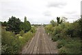
Towards Didcot
View of the rail lines in the Didcot direction.
Image: © Bill Nicholls
Taken: 7 Sep 2011
0.07 miles