IMAGES TAKEN NEAR TO
Orchard Way, ABINGDON, OX13 6PP
Introduction
This page details the photographs taken nearby to Orchard Way, OX13 6PP by members of the Geograph project.
The Geograph project started in 2005 with the aim of publishing, organising and preserving representative images for every square kilometre of Great Britain, Ireland and the Isle of Man.

There are currently over 7.5m images from over14,400 individuals and you can help contribute to the project by visiting https://www.geograph.org.uk
Image Map (Loading...)


Getting Data...Please wait
Leaflet Map data © OpenStreetMap
Images are licensed for reuse under creativecommons.org/licenses/by-sa/2.0
Notes
- Clicking on the map will re-center to the selected point.
- The higher the marker number, the further away the image location is from the centre of the postcode.
Image Listing (49 Images Found)
Images are licensed for reuse under creativecommons.org/licenses/by-sa/2.0
Image
Details
Distance
1
Hyde Copse, Marcham
Hydes Copse is a small wood just off to the left of this shot.
Image: © Des Blenkinsopp
Taken: 7 Jan 2014
0.12 miles
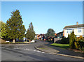
2
Junction of Howard Cornish Road and Anson Close
Image: © Basher Eyre
Taken: 26 Mar 2022
0.13 miles
3
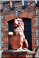
The Red Lion
One of the terra cotta lions outside the hall shown in Image
Image: © Des Blenkinsopp
Taken: 24 Mar 2010
0.15 miles
5
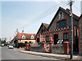
Church Hall, Marcham
An Englishman's church hall is his castle.
Battlements and lions (and a saint) ornament this brick hall in Marcham's main street.
I have put in a supplemental of one of the lions. They're rather splendid. Image
Incidentally, Marcham apparently comes from Saxon "Merceham" meaning place where celery grows.
Update:- In a previous caption I expressed some doubt re. the above but got this mail from a reader "Wild celery derivation is true (it still grows there if you know where to look). I used to live in the village." So, Celery it is, and caption modified accordingly. Thank you.
Update 2:- from the foundation stone on the front of the building, which reads :-
AD 1903
Marcham Church Institute
This stone was laid December 6th
The Feast of St. Nicholas.
So that would be who the saint is, then.
Image: © Des Blenkinsopp
Taken: 24 Mar 2010
0.16 miles
7
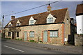
Houses on Packhorse Lane
Repairs to the brickwork on the near house (#43) have destroyed an Ordnance Survey benchmark on its near corner.
Image: © Roger Templeman
Taken: 16 Feb 2013
0.17 miles
8
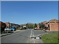
North Street
View down North Street in Marcham from New Road.
Image: © Bill Nicholls
Taken: 17 Sep 2011
0.17 miles
9
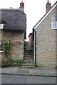
Footpath between the houses
Footpath leading between the houses along North Street and leads to Packhorse Lane
Image: © Bill Nicholls
Taken: 17 Sep 2011
0.17 miles
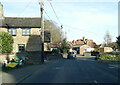
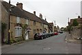
10
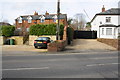
Houses on NW side of Packhorse Lane
There is an OS benchmark Image at the end of the wall in the middle of the image. The house on the right is The Red House, which seems odd given its colour!
Image: © Roger Templeman
Taken: 16 Feb 2013
0.17 miles