IMAGES TAKEN NEAR TO
Abbots Grange, ABINGDON, OX13 6PF
Introduction
This page details the photographs taken nearby to Abbots Grange, OX13 6PF by members of the Geograph project.
The Geograph project started in 2005 with the aim of publishing, organising and preserving representative images for every square kilometre of Great Britain, Ireland and the Isle of Man.

There are currently over 7.5m images from over14,400 individuals and you can help contribute to the project by visiting https://www.geograph.org.uk
Image Map
Images are licensed for reuse under creativecommons.org/licenses/by-sa/2.0
Notes
- Clicking on the map will re-center to the selected point.
- The higher the marker number, the further away the image location is from the centre of the postcode.
Image Listing (68 Images Found)
Images are licensed for reuse under creativecommons.org/licenses/by-sa/2.0
Image
Details
Distance
1
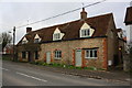
Nos. 41 and 43 Packhorse Lane (A415)
Image: © Roger Templeman
Taken: 12 Jan 2016
0.07 miles
2
Benchmark on wall end on Packhorse Lane
Ordnance Survey cut mark benchmark described on the Bench Mark Database at http://www.bench-marks.org.uk/bm47248
Image: © Roger Templeman
Taken: 16 Feb 2013
0.07 miles
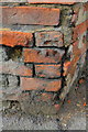
3
Houses on Packhorse Lane
Repairs to the brickwork on the near house (#43) have destroyed an Ordnance Survey benchmark on its near corner.
Image: © Roger Templeman
Taken: 16 Feb 2013
0.07 miles
4
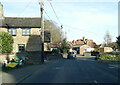
Towards Packhorse Lane
View along the road beside the Crown Public house, Packhorse Lane.
Image: © Bill Nicholls
Taken: 17 Sep 2011
0.08 miles
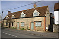
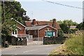
5
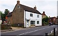
Former shop in Packhorse Lane, Marcham, Oxon
Judging by the type of central window this was almost certainly at one time a shop. The window is fairly new and previously there was a slightly curved window very much in the style used in Victorian shops. The building is now a private house.
Image: © P L Chadwick
Taken: 20 Jul 2014
0.08 miles
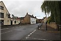
6
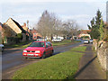
Village green, Marcham
From the junction of Priory Lane and Mill Road looking north. Mid-day Christmas Day.
Image: © Dave Dunford
Taken: 25 Dec 2005
0.08 miles
7
Houses on NW side of Packhorse Lane
There is an OS benchmark Image at the end of the wall in the middle of the image. The house on the right is The Red House, which seems odd given its colour!
Image: © Roger Templeman
Taken: 16 Feb 2013
0.08 miles
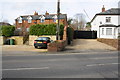
10

The Crown, Marcham
Built in C18 as a house originally. See http://www.britishlistedbuildings.co.uk/en-249665-the-crown-public-house-marcham-oxfordshi for entry in British Listed Buildings
Image: © Bikeboy
Taken: 18 Feb 2015
0.08 miles