IMAGES TAKEN NEAR TO
Gozzards Ford, ABINGDON, OX13 6JH
Introduction
This page details the photographs taken nearby to OX13 6JH by members of the Geograph project.
The Geograph project started in 2005 with the aim of publishing, organising and preserving representative images for every square kilometre of Great Britain, Ireland and the Isle of Man.

There are currently over 7.5m images from over14,400 individuals and you can help contribute to the project by visiting https://www.geograph.org.uk
Image Map
Images are licensed for reuse under creativecommons.org/licenses/by-sa/2.0
Notes
- Clicking on the map will re-center to the selected point.
- The higher the marker number, the further away the image location is from the centre of the postcode.
Image Listing (29 Images Found)
Images are licensed for reuse under creativecommons.org/licenses/by-sa/2.0
Image
Details
Distance
1
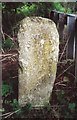
Old Boundary Marker by Gozzard's Ford, St Helen Without parish
Parish Boundary Marker by the UC road, in parish of St Helen Without (Vale of White Horse District), Gozzard's Ford, junction with Faringdon Road, on inside of bend behind crash barrier. See https://www.geograph.org.uk/photo/4763264 for Marcham Parish face.
Inscription reads:-
ST HELEN
PARISH
ABINGDON
Surveyed
Milestone Society National ID: BE_LG57pb
Image: © Roger Templeman
Taken: Unknown
0.02 miles
2
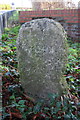
Gozzard's Ford boundary stone: Marcham Parish face
The St Helen Abingdon Parish face at Image
Image: © Roger Templeman
Taken: 9 Dec 2015
0.02 miles
3
Cancelled benchmark on Gozzard's Ford boundary stone
Cancelled cut mark benchmark described on the Bench Mark Database at http://www.bench-marks.org.uk/bm36313 . The inscription is St Helen Parish Abingdon
Image: © Roger Templeman
Taken: 9 Dec 2015
0.02 miles
4
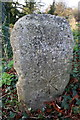
Boundary stone behind crash barrier at Gozzard's Ford
Image: © Roger Templeman
Taken: 9 Dec 2015
0.03 miles
5
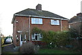
Nos. 52 and 50 Faringdon Road
There is an OS benchmark Image on the left hand side of No. 52 near its front corner
Image: © Roger Templeman
Taken: 9 Dec 2015
0.05 miles
6
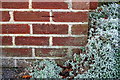
Benchmark on #52 Faringdon Road
Ordnance Survey cut mark benchmark described on the Bench Mark Database at http://www.bench-marks.org.uk/bm72564
Image: © Roger Templeman
Taken: 9 Dec 2015
0.06 miles
7
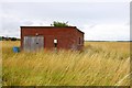
Disused military building at Dalton Barracks
Image: © Steve Daniels
Taken: 17 Jul 2009
0.08 miles
8
The perimeter fence at Dalton Barracks
Image: © Steve Daniels
Taken: 17 Jul 2009
0.10 miles
9
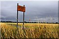
Danger. Keep out!
Sign at the perimeter of Dalton Barracks
Image: © Steve Daniels
Taken: 17 Jul 2009
0.11 miles
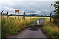
10
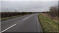
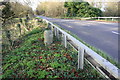
Faringdon Road
Faringdon Road heading to Marcham Road
Image: © Shaun Ferguson
Taken: 10 Jan 2022
0.15 miles