IMAGES TAKEN NEAR TO
Conway Road, ABINGDON, OX13 6HQ
Introduction
This page details the photographs taken nearby to Conway Road, OX13 6HQ by members of the Geograph project.
The Geograph project started in 2005 with the aim of publishing, organising and preserving representative images for every square kilometre of Great Britain, Ireland and the Isle of Man.

There are currently over 7.5m images from over14,400 individuals and you can help contribute to the project by visiting https://www.geograph.org.uk
Image Map (Loading...)


Getting Data...Please wait
Leaflet Map data © OpenStreetMap
Images are licensed for reuse under creativecommons.org/licenses/by-sa/2.0
Notes
- Clicking on the map will re-center to the selected point.
- The higher the marker number, the further away the image location is from the centre of the postcode.
Image Listing (8 Images Found)
Images are licensed for reuse under creativecommons.org/licenses/by-sa/2.0
Image
Details
Distance
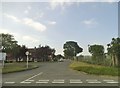
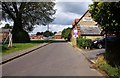
2
Nene Road, Shippon
Apart from an area of old housing around the church, most of Shippon is a military village centred on Dalton Barracks and Abingdon airfield.
The housing pretty much all looks like this and most of the people around are in the army.
Image: © Des Blenkinsopp
Taken: 1 Nov 2011
0.09 miles
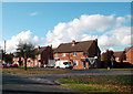
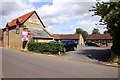
4
Cholswell Road, Shippon
Apart from an area of old housing around the church, most of Shippon is a military village centred on Dalton Barracks and Abingdon airfield.
The housing pretty much all looks like this and most of the people around are in the army.
Image: © Des Blenkinsopp
Taken: 1 Nov 2011
0.15 miles
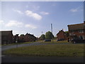
5
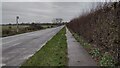
Long Tow
Long tow heading to Shippon
Image: © Shaun Ferguson
Taken: 10 Jan 2022
0.16 miles
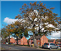
8
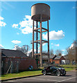
MG and Water Tank
This little two seater would have been made just down the road in Abingdon.
Image: © Des Blenkinsopp
Taken: 19 Mar 2012
0.22 miles