IMAGES TAKEN NEAR TO
Brind Close, ABINGDON, OX13 6FG
Introduction
This page details the photographs taken nearby to Brind Close, OX13 6FG by members of the Geograph project.
The Geograph project started in 2005 with the aim of publishing, organising and preserving representative images for every square kilometre of Great Britain, Ireland and the Isle of Man.

There are currently over 7.5m images from over14,400 individuals and you can help contribute to the project by visiting https://www.geograph.org.uk
Image Map
Images are licensed for reuse under creativecommons.org/licenses/by-sa/2.0
Notes
- Clicking on the map will re-center to the selected point.
- The higher the marker number, the further away the image location is from the centre of the postcode.
Image Listing (153 Images Found)
Images are licensed for reuse under creativecommons.org/licenses/by-sa/2.0
Image
Details
Distance
1
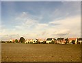
Farmland at Steventon
View across Causeway farmland at Steventon.
Image: © Alan Hughes
Taken: 27 Oct 2016
0.02 miles
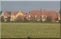
2

Looking towards Steventon
Across fields (with tree and power lines) looking towards edge of village of Steventon. Taken from railway line when approaching Didcot Parkway.
Image: © Clint Mann
Taken: 2 Oct 2015
0.05 miles
4
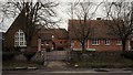
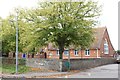
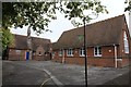
Steventon Primary School
The two main buildings by J W Hugall (left) and G E Street (right), linked by additions of about 1900.
Image: © Chris Brown
Taken: 19 Feb 2017
0.08 miles
5

Benchmark on St Michaels School
I came back and asked if I could get the photo which shows it is in good condition. Image
Image: © Bill Nicholls
Taken: 9 Sep 2011
0.09 miles
6
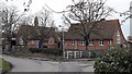
Steventon Primary School
The schoolroom on the right was designed by G E Street in 1861-64; the former infants' school with the bellcote is by J W Hugall in 1871. The school is seen from the causeway and along with the North Star pub opposite marks the point where the village green ends and a village street, still known as the Causeway, continues to the church.
Image: © Chris Brown
Taken: 19 Feb 2017
0.09 miles
7

Mural on the wall
The mural looks like it has been done by the school children and put on display.
Image: © Bill Nicholls
Taken: 8 Sep 2011
0.09 miles
8
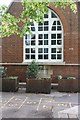
Date stone under the window
The date on the stone is 1900 though from this distance is to read because of the plants in the tub. To the left on the corner is a benchmark.
Image: © Bill Nicholls
Taken: 8 Sep 2011
0.09 miles
9
St Michael's School
ST Michael's school in Steventon, this is the older part in the photo.
Image: © Bill Nicholls
Taken: 7 Sep 2011
0.09 miles
10
The School yard
The school playground at St Michaels in Steventon.
Image: © Bill Nicholls
Taken: 8 Sep 2011
0.09 miles