IMAGES TAKEN NEAR TO
Green Close, ABINGDON, OX13 6EX
Introduction
This page details the photographs taken nearby to Green Close, OX13 6EX by members of the Geograph project.
The Geograph project started in 2005 with the aim of publishing, organising and preserving representative images for every square kilometre of Great Britain, Ireland and the Isle of Man.

There are currently over 7.5m images from over14,400 individuals and you can help contribute to the project by visiting https://www.geograph.org.uk
Image Map (Loading...)


Getting Data...Please wait
Leaflet Map data © OpenStreetMap
Images are licensed for reuse under creativecommons.org/licenses/by-sa/2.0
Notes
- Clicking on the map will re-center to the selected point.
- The higher the marker number, the further away the image location is from the centre of the postcode.
Image Listing (79 Images Found)
Images are licensed for reuse under creativecommons.org/licenses/by-sa/2.0
Image
Details
Distance
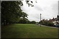
1
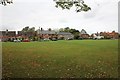
Across The Green
Wider view of The Green in Steventon, this part is where you usually see the visiting fairs.
Image: © Bill Nicholls
Taken: 7 Sep 2011
0.07 miles
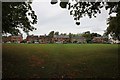
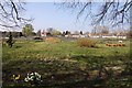
2
Path across the green
You can just make out a well trodden footpath which leads across the Green in Steventon towards some of the older houses of the area.
Image: © Bill Nicholls
Taken: 7 Sep 2011
0.07 miles
3

Fire Mark on The Green
While looking for date plaques or anything interesting I noticed a fire mark on one of the houses which I had to get. This caused a person to ask what I was up to; when I replied "Taking photos of the village," he said, "Oh, it is just I noticed you taking pictures of the house." I replied that it was the fire mark to which he replied there were more along the causeway. He was not wrong and many thanks to him.
You can just make the mark out on the white house to the right of the photo. Image
Image: © Bill Nicholls
Taken: 7 Sep 2011
0.08 miles
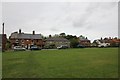
4
Houses on The Green
View of the houses along the East Side of The Green in Steventon.
Image: © Bill Nicholls
Taken: 7 Sep 2011
0.08 miles
5
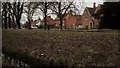
West side of Steventon Green
Looking across the drainage channel and Abingdon Road to the west side of the green as it curves road to meet the Hanney road.
Image: © Chris Brown
Taken: 19 Feb 2017
0.09 miles
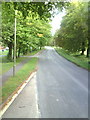
6

Hanney Road
Hanney Road by The Green in Steventon which surprisingly goes to Hanney.
Image: © Bill Nicholls
Taken: 7 Sep 2011
0.09 miles
7
The Green Odd numbers
View of The Green in Steventon with the odd numbered housing.
Image: © Bill Nicholls
Taken: 7 Sep 2011
0.10 miles
9
Abingdon Road where it passes The Green
Image: © Roger Templeman
Taken: 15 Sep 2010
0.10 miles
10
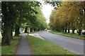
High Street through the green
View along the High Street as it passes through The Green in Steventon.
Image: © Bill Nicholls
Taken: 7 Sep 2011
0.10 miles