IMAGES TAKEN NEAR TO
Hawthorne Avenue, ABINGDON, OX13 6ES
Introduction
This page details the photographs taken nearby to Hawthorne Avenue, OX13 6ES by members of the Geograph project.
The Geograph project started in 2005 with the aim of publishing, organising and preserving representative images for every square kilometre of Great Britain, Ireland and the Isle of Man.

There are currently over 7.5m images from over14,400 individuals and you can help contribute to the project by visiting https://www.geograph.org.uk
Image Map
Images are licensed for reuse under creativecommons.org/licenses/by-sa/2.0
Notes
- Clicking on the map will re-center to the selected point.
- The higher the marker number, the further away the image location is from the centre of the postcode.
Image Listing (11 Images Found)
Images are licensed for reuse under creativecommons.org/licenses/by-sa/2.0
Image
Details
Distance
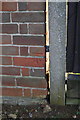
1
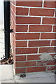
Benchmark on #1 Sycamore Close
Ordnance Survey cut mark benchmark described on the Bench Mark Database at http://www.bench-marks.org.uk/bm40505
Image: © Roger Templeman
Taken: 10 Dec 2011
0.10 miles
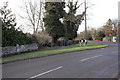
2
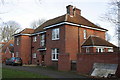
#1 Sycamore Close
There is an OS benchmark Image inside the rear porch of this house
Image: © Roger Templeman
Taken: 10 Dec 2011
0.10 miles
3
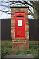
Benchmark on letter box, Faringdon Road
Ordnance Survey cut mark benchmark described on the Bench Mark Database at http://www.bench-marks.org.uk/bm23438
Image: © Roger Templeman
Taken: 10 Dec 2011
0.13 miles
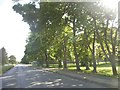
4
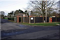
Entrance to Dalton Barracks from Faringdon Road
On the right is a GR post box which has an OS benchmark Image
Image: © Roger Templeman
Taken: 10 Dec 2011
0.13 miles
5
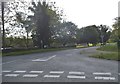
Faringdon Road at the junction of Choleswell Road
Image: © David Howard
Taken: 29 May 2016
0.13 miles
7
Old Milestone by Faringdon Road, Shippon
Carved stone post by the UC road, in parish of ST HELEN WITHOUT (VALE OF WHITE HORSE District), Faringdon Road, Shippon, Abingdon Airfield, within a stone wall, on West side of road. Henley limestone pillar, erected by the Abingdon & Fyfield turnpike trust in the 18th century.
Inscription reads:-
(ABINGDON)
(1)
(FARINGDON)
1(3)
Carved benchmark lower part of front face.
Milestone Society National ID: BE_LG57.
Image: © A Rosevear
Taken: 2 Sep 2001
0.16 miles
8
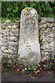
Benchmark on milestone, Faringdon Road
Ordnance Survey cut mark benchmark described on the Bench Mark Database at http://www.bench-marks.org.uk/bm22637
Image: © Roger Templeman
Taken: 10 Dec 2011
0.16 miles
9
Junction in Faringdon Road
There is a milestone with an OS benchmark Image in the wall at the left of the photograph
Image: © Roger Templeman
Taken: 10 Dec 2011
0.16 miles
10
Benchmark on #39 Sycamore Close
Ordnance Survey cut mark benchmark described on the Bench Mark Database at http://www.bench-marks.org.uk/bm40504
Image: © Roger Templeman
Taken: 10 Dec 2011
0.23 miles