IMAGES TAKEN NEAR TO
Whitecross, ABINGDON, OX13 6BT
Introduction
This page details the photographs taken nearby to Whitecross, OX13 6BT by members of the Geograph project.
The Geograph project started in 2005 with the aim of publishing, organising and preserving representative images for every square kilometre of Great Britain, Ireland and the Isle of Man.

There are currently over 7.5m images from over14,400 individuals and you can help contribute to the project by visiting https://www.geograph.org.uk
Image Map (Loading...)


Getting Data...Please wait
Leaflet Map data © OpenStreetMap
Images are licensed for reuse under creativecommons.org/licenses/by-sa/2.0
Notes
- Clicking on the map will re-center to the selected point.
- The higher the marker number, the further away the image location is from the centre of the postcode.
Image Listing (7 Images Found)
Images are licensed for reuse under creativecommons.org/licenses/by-sa/2.0
Image
Details
Distance
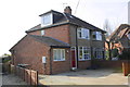
1
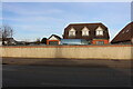
Whitecross, Wootton Road
Whitecross is a ribbon development alongside the B4017 between Abingdon and Wootton.
Image: © Des Blenkinsopp
Taken: 30 Jul 2011
0.03 miles
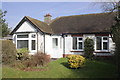
2
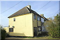
#170 White Cross
The rendering on the side of the house probably conceals an Ordnance Survey benchmark
Image: © Roger Templeman
Taken: 4 Mar 2013
0.05 miles
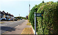
5
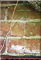
Benchmark on #181 White Cross
Ordnance Survey cut mark benchmark described on the Bench Mark Database at http://www.bench-marks.org.uk/bm47497
Image: © Roger Templeman
Taken: 4 Mar 2013
0.18 miles
6
#181 White Cross
There is an OS benchmark Image on the brickwork below the bay window
Image: © Roger Templeman
Taken: 4 Mar 2013
0.18 miles