IMAGES TAKEN NEAR TO
Sunningwell Road, ABINGDON, OX13 6BJ
Introduction
This page details the photographs taken nearby to Sunningwell Road, OX13 6BJ by members of the Geograph project.
The Geograph project started in 2005 with the aim of publishing, organising and preserving representative images for every square kilometre of Great Britain, Ireland and the Isle of Man.

There are currently over 7.5m images from over14,400 individuals and you can help contribute to the project by visiting https://www.geograph.org.uk
Image Map
Images are licensed for reuse under creativecommons.org/licenses/by-sa/2.0
Notes
- Clicking on the map will re-center to the selected point.
- The higher the marker number, the further away the image location is from the centre of the postcode.
Image Listing (14 Images Found)
Images are licensed for reuse under creativecommons.org/licenses/by-sa/2.0
Image
Details
Distance
2
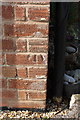
Benchmark on Long Furlong Farm
Ordnance Survey cut mark benchmark described on the Bench Mark Database at http://www.bench-marks.org.uk/bm47498
Image: © Roger Templeman
Taken: 4 Mar 2013
0.04 miles
3
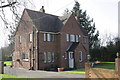
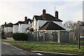
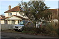
Long Furlong Farm, Sunningwell Road
There is an OS benchmark Image on the side of the house at the near corner
Image: © Roger Templeman
Taken: 4 Mar 2013
0.04 miles
4
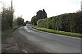
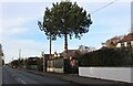
Long Furlong Road, Whitecross
This is just outside the edge of Abingdon.
Image: © David Howard
Taken: 5 Feb 2023
0.05 miles
5
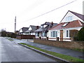
Houses on Longfurlong Road
A cul-de-sac off the B4017 north of Abingdon.
Image: © Jonathan Billinger
Taken: 10 Jan 2007
0.06 miles
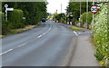
8
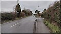
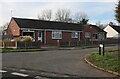
Wootton Road
Wootton Road B4017 passing the turn to Sunningwell entering Whitecross
Image: © Shaun Ferguson
Taken: 10 Jan 2022
0.13 miles
10
North along Wootton Road in Whitecross
Image: © Mat Fascione
Taken: 15 Jun 2015
0.14 miles