IMAGES TAKEN NEAR TO
Netherton, ABINGDON, OX13 5LT
Introduction
This page details the photographs taken nearby to OX13 5LT by members of the Geograph project.
The Geograph project started in 2005 with the aim of publishing, organising and preserving representative images for every square kilometre of Great Britain, Ireland and the Isle of Man.

There are currently over 7.5m images from over14,400 individuals and you can help contribute to the project by visiting https://www.geograph.org.uk
Image Map (Loading...)


Getting Data...Please wait
Leaflet Map data © OpenStreetMap
Images are licensed for reuse under creativecommons.org/licenses/by-sa/2.0
Notes
- Clicking on the map will re-center to the selected point.
- The higher the marker number, the further away the image location is from the centre of the postcode.
Image Listing (17 Images Found)
Images are licensed for reuse under creativecommons.org/licenses/by-sa/2.0
Image
Details
Distance
2
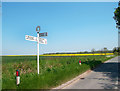
Oxfordshire Signpost at Netherton
Another of our trademark county signposts.
Image: © Des Blenkinsopp
Taken: 22 May 2012
0.05 miles
5
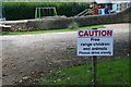
Free range Children
I love this sign but I saw no children running wild as we walked up the road, let alone animals.
Image: © Bill Nicholls
Taken: 23 Aug 2009
0.06 miles
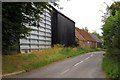
6
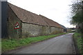
Barns of Stone's Farm, Netherton Lane
There is an OS benchmark Image on the corner of the near barn on its road face
Image: © Roger Templeman
Taken: 4 Feb 2016
0.06 miles
7
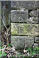
Benchmark on Stone's Farm barn
Ordnance Survey cut mark benchmark described on the Bench Mark Database at http://www.bench-marks.org.uk/bm50241
Image: © Roger Templeman
Taken: 4 Feb 2016
0.07 miles
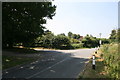
9
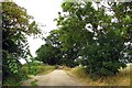
Marsh Lane in Netherton
Marsh Lane leads to Marsh Farm.
Image: © Steve Daniels
Taken: 3 Sep 2013
0.08 miles
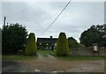
10
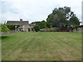
Stones Farm house and bee boles
Late 17th-early 18th century Grade II listed Cotswold stone farmhouse. To the right of the picture is a wall with bee boles that is part of the listing.
https://britishlistedbuildings.co.uk/101368567-stones-farmhouse-and-attached-walls-fyfield-and-tubney#.XTAgemeWyUk
Bee boles are cavities or alcoves in walls in which skeps are placed to keep them away from the wind and rain. https://en.wikipedia.org/wiki/Bee_bole
See also Image]
Image: © Vieve Forward
Taken: 17 Jul 2019
0.09 miles