IMAGES TAKEN NEAR TO
College Square, ABINGDON, OX13 5ES
Introduction
This page details the photographs taken nearby to College Square, OX13 5ES by members of the Geograph project.
The Geograph project started in 2005 with the aim of publishing, organising and preserving representative images for every square kilometre of Great Britain, Ireland and the Isle of Man.

There are currently over 7.5m images from over14,400 individuals and you can help contribute to the project by visiting https://www.geograph.org.uk
Image Map
Images are licensed for reuse under creativecommons.org/licenses/by-sa/2.0
Notes
- Clicking on the map will re-center to the selected point.
- The higher the marker number, the further away the image location is from the centre of the postcode.
Image Listing (40 Images Found)
Images are licensed for reuse under creativecommons.org/licenses/by-sa/2.0
Image
Details
Distance
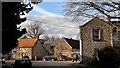
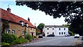
1
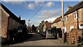
Tucks Lane, Longworth
Tucks Lane leads north out of the Square.
Image: © Chris Brown
Taken: 24 Feb 2017
0.01 miles
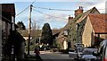
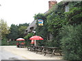
3
Blue Boar, Tucks Lane
Threatening sky brought a few hail stones, then sunshine
Image: © Roger Templeman
Taken: 2 Feb 2016
0.01 miles
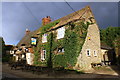
4
The Blue Boar on Tuck's Lane
The Blue Boar is a former Morrells pub.
Image: © Steve Daniels
Taken: 3 Sep 2013
0.01 miles
5
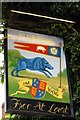
The Blue Boar sign
The Blue Boar is a former Morrells pub.
Image: © Steve Daniels
Taken: 3 Sep 2013
0.01 miles
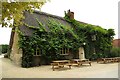
6
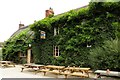
The Blue Boar on Tuck's Lane
The Blue Boar is a former Morrells pub.
Image: © Steve Daniels
Taken: 3 Sep 2013
0.01 miles
7
Tucks Lane and the Blue Boar, Longworth
Image: © Chris Brown
Taken: 24 Feb 2017
0.02 miles
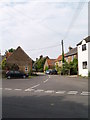
9
The Square, Longworth
The white house is the old post office.
Image: © Des Blenkinsopp
Taken: 27 Jun 2013
0.03 miles
10
The Blue Boar, Tuck's Lane, Longworth
Image: © Roger Cornfoot
Taken: 11 Aug 2009
0.04 miles