IMAGES TAKEN NEAR TO
Kingston Bagpuize, ABINGDON, OX13 5AW
Introduction
This page details the photographs taken nearby to OX13 5AW by members of the Geograph project.
The Geograph project started in 2005 with the aim of publishing, organising and preserving representative images for every square kilometre of Great Britain, Ireland and the Isle of Man.

There are currently over 7.5m images from over14,400 individuals and you can help contribute to the project by visiting https://www.geograph.org.uk
Image Map (Loading...)


Getting Data...Please wait
Leaflet Map data © OpenStreetMap
Images are licensed for reuse under creativecommons.org/licenses/by-sa/2.0
Notes
- Clicking on the map will re-center to the selected point.
- The higher the marker number, the further away the image location is from the centre of the postcode.
Image Listing (110 Images Found)
Images are licensed for reuse under creativecommons.org/licenses/by-sa/2.0
Image
Details
Distance
1
New housing and electricity substation, Faringdon Road
In 1856 the Kingston Bagpuize Toll House, http://www.bench-marks.org.uk/bm20151 , occupied this site
Image: © Roger Templeman
Taken: 13 Jan 2016
0.02 miles
2

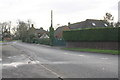
Electricity substation by the A415 road, Kingston Bagpuize, Oxon
The substation is near the mini-roundabout at the junction of the A415 and Faringdon Road.
Image: © P L Chadwick
Taken: 25 Feb 2018
0.02 miles
3

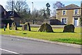
War memorials in Kingston Bagpuize
The names on the plaques are in time order rather than alphabetical. The memorial was erected in 2012.
Image: © Steve Daniels
Taken: 6 May 2013
0.03 miles
4
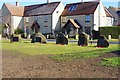
War Memorial Crescent (1), Village Green, Kingston Bagpuize, Oxon
A very unusual war memorial erected as recently as 2012 and consisting of five stones. The stones themselves are 150 million year old Corallian limestones with inset Welsh slate plaques. The memorial relates to both World Wars and much more. A detailed description can be found on the War Memorials Online website run by the War Memorials Trust with the support of Historic England. Reference WMO125540.
The Village Green is located between the A415 (Witney Road) and Oxford Road.
Image
Image
Image: © P L Chadwick
Taken: 25 Feb 2018
0.03 miles
5
War Memorial Crescent (2), Village Green, Kingston Bagpuize, Oxon
Image: © P L Chadwick
Taken: 25 Feb 2018
0.03 miles
6
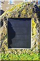
War Memorial Crescent (3) - story of the stones, Village Green, Kingston Bagpuize, Oxon
This plaque on one of the stones tells their story and that of the Memorial. It reads: - Ancient Local Stones. These ancient stones were donated by Oxfordshire County Council and placed in position near Draycott Road in 1992 by Edmund Nuttall, Bypass Construction Engineers, at the instigation of Richard F. Cox, a local farmer from Southmoor, who wanted to create a Southmoor Henge. The five stones were taken from the land bordering Southmoor and Longworth at the time of the bypass construction, 1992/93, and retained to commemorate the new highway. They were also used as a boundary marker between land owned by St. John's College and land owned by Mr Cox. Archaeologists from the University Museum, Oxford, advise that these Corrallian limestone rocks are 150 million years old and were formed when grains of sand were deposited and cemented together by lime in what was a warm shallow sea that once covered present day Oxfordshire. In October 2012, with the agreement of the late Mr Cox's family, the stones were removed by Cliff Belcher and his sons to this new position to form the Kingston Bagpuize with Southmoor War Memorial - a natural and lasting tribute to those who sacrifice for their country and the freedoms we enjoy."
Image
Image
Image: © P L Chadwick
Taken: 25 Feb 2018
0.03 miles
7
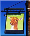
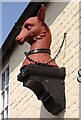
The former Hinds Head (2) - sign, Witney Road, Kingston Bagpuize, Oxon
The sign of the former Hinds Head public house. The blacked out lower portion probably originally showed the name of brewers Greene King who owned the pub until 2014. The site is to be used for a new Sainsbury's supermarket.
Image
Image
Image
Image: © P L Chadwick
Taken: 25 Feb 2018
0.03 miles
8
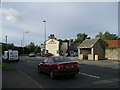
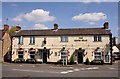
The Hind's Head, Kingston Bagpuize
Looking north
Image: © Alec Samler
Taken: 29 Sep 2004
0.03 miles