IMAGES TAKEN NEAR TO
Faringdon Road, ABINGDON, OX13 5AQ
Introduction
This page details the photographs taken nearby to Faringdon Road, OX13 5AQ by members of the Geograph project.
The Geograph project started in 2005 with the aim of publishing, organising and preserving representative images for every square kilometre of Great Britain, Ireland and the Isle of Man.

There are currently over 7.5m images from over14,400 individuals and you can help contribute to the project by visiting https://www.geograph.org.uk
Image Map (Loading...)


Getting Data...Please wait
Leaflet Map data © OpenStreetMap
Images are licensed for reuse under creativecommons.org/licenses/by-sa/2.0
Notes
- Clicking on the map will re-center to the selected point.
- The higher the marker number, the further away the image location is from the centre of the postcode.
Image Listing (91 Images Found)
Images are licensed for reuse under creativecommons.org/licenses/by-sa/2.0
Image
Details
Distance
1
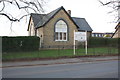
Scout Hall, Faringdon Road
There is an OS benchmark Image under the window on the front face of this former school
Image: © Roger Templeman
Taken: 2 Feb 2016
0.02 miles
2
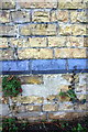
Benchmark on Scout Hall
Ordnance Survey cut mark benchmark described on the Bench Mark Database at http://www.bench-marks.org.uk/bm73470
Image: © Roger Templeman
Taken: 2 Feb 2016
0.02 miles
3
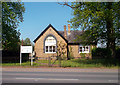
Old Schoolhouse, Kingston Bagpuize
Now used by the Longworth Scouts.
Image: © Des Blenkinsopp
Taken: 22 May 2012
0.02 miles
4
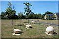
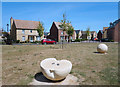
Stone Apples on the Green
Fruit sculpture in a small park off Chadelworth Way.
Kingston Bagpuize used to be a fruit growing area and in 1953 a variety of apple, the Queen Cox, was first identified on a local farm.
Image: © Des Blenkinsopp
Taken: 28 May 2020
0.07 miles
5
Half an Apple, Chadelworth Way
One of a collection of sculptured apples on a small green in a new residential area.
Kingston Bagpuize used to be a fruit growing area and in 1953 a variety of apple, the Queen Cox, was first identified on a local farm.
Image: © Des Blenkinsopp
Taken: 28 May 2020
0.07 miles
7
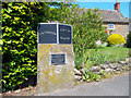
Parish Boundary Stone
Between Southmoor and Kingston Bagpuize.
The inscription says :-
To commemorate the centenary of parish councils 1894 - 1994 this being the original boundary between the parish of Longworth and Kingston Bagpuize.
It is by the roadside almost opposite the post office.
Image: © Des Blenkinsopp
Taken: 22 May 2012
0.09 miles
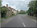
8
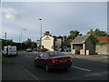
The Hind's Head, Kingston Bagpuize
Looking north
Image: © Alec Samler
Taken: 29 Sep 2004
0.10 miles
10

The former Hinds Head (3) - detail, Witney Road, Kingston Bagpuize, Oxon
As well as a conventional sign this now closed public house also had this sculpture of a hind's head on the outside wall facing Witney Road.
Image
Image
Image
Image: © P L Chadwick
Taken: 25 Feb 2018
0.10 miles