IMAGES TAKEN NEAR TO
Great Mead, OXFORD, OX1 2RB
Introduction
This page details the photographs taken nearby to Great Mead, OX1 2RB by members of the Geograph project.
The Geograph project started in 2005 with the aim of publishing, organising and preserving representative images for every square kilometre of Great Britain, Ireland and the Isle of Man.

There are currently over 7.5m images from over14,400 individuals and you can help contribute to the project by visiting https://www.geograph.org.uk
Image Map (Loading...)


Getting Data...Please wait
Leaflet Map data © OpenStreetMap
Images are licensed for reuse under creativecommons.org/licenses/by-sa/2.0
Notes
- Clicking on the map will re-center to the selected point.
- The higher the marker number, the further away the image location is from the centre of the postcode.
Image Listing (955 Images Found)
Images are licensed for reuse under creativecommons.org/licenses/by-sa/2.0
Image
Details
Distance
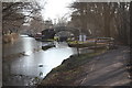
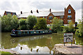
2
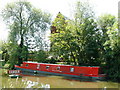
Oxford - Canal Boat on the River
This boat is moored on the river, which appears to be one of the branches of the River Thames which flow through Oxford.
Image: © Peter Trimming
Taken: 30 May 2009
0.02 miles
5
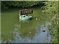
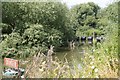
Danger buoy on the Castle Mill Stream
Probably intended to deter boaters from continuing downstream, it certainly didn't deter ducks from nesting.
Image: © Stephen Craven
Taken: 21 Sep 2021
0.02 miles
6
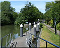
Mooring pontoon at Castle Mill Stream Junction
This junction is where the Oxford Canal joins the Sheepwash Channel, which leads to the River Thames.
Image: © Mat Fascione
Taken: 15 Jun 2015
0.02 miles
7
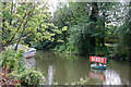
Danger Buoy
Anchored in a backwater of the River Thames - actually the Old Navigation or Castle Mill Stream - beside the Oxford Canal. The danger consists of shallow water, a low bridge at Hythe bridge Street and a weir where the castle mill used to be. Perhaps it is also a warning that the ducks bite!
Image: © Martin Addison
Taken: 11 Aug 2010
0.03 miles
8
Oxford Canal
Isis lock on the Oxford Canal. It's difficult to believe that the city centre is only a short walk away.
Image: © Ralph Tucker
Taken: 16 Jan 2012
0.03 miles
9
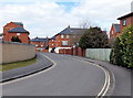
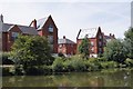
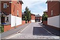
Rewley Road houses, Oxford
This is the residential part of Rewley Road, north of the fire station. http://www.geograph.org.uk/photo/3389617
Image: © Jaggery
Taken: 31 Mar 2013
0.03 miles
10
Takara Takes The Turn
Takara, a hotel boat according to the signwriting on the side, swings slowly around to enter Isis Lock and join the Oxford Canal from the River Thames. The sign in the foreground indicates the direction to be taken to join the river. There is also a sign, visible behind the narrowboat which indicates the channel as being in that direction. Moving right to left through this area of open water is the Old Navigation - now too shallow in parts for anything other than canoes and punts. The apartments beyond are on an estate beside Rewley Road.
Image: © Martin Addison
Taken: 11 Aug 2010
0.03 miles