
IMAGES TAKEN NEAR TO
Childrey, WANTAGE, OX12 9UT
Introduction
This page details the photographs taken nearby to OX12 9UT by members of the Geograph project.
The Geograph project started in 2005 with the aim of publishing, organising and preserving representative images for every square kilometre of Great Britain, Ireland and the Isle of Man.

There are currently over 7.5m images from over14,400 individuals and you can help contribute to the project by visiting https://www.geograph.org.uk
Image Map
Images are licensed for reuse under creativecommons.org/licenses/by-sa/2.0
Notes
- Clicking on the map will re-center to the selected point.
- The higher the marker number, the further away the image location is from the centre of the postcode.
Image Listing (158 Images Found)
Images are licensed for reuse under creativecommons.org/licenses/by-sa/2.0
Image
Details
Distance
1

Church Row, Childrey
Looking towards the church on Church Row.
Image: © Oscar Taylor
Taken: 27 Jun 2023
0.05 miles
2

Childrey school wall carving
A carving on a plaque in a wall on Church Row in Childrey. The plaque (roughly) reads "Laus Deo et Gloria
This School was erected at the ſole
Charge of Sr GEORGE FETTYPLACE
Bar for the Benefit of the Children of
Childrey for ever. Ano J732 with an
Augmentation of ey Salery given by his
Predeceſsor in ey Reign of Henry ey Eight"
Forever wasn't very long, as the school is now a house.
Image: © Oscar Taylor
Taken: 27 Jun 2023
0.06 miles
3

Chapel Way, Childrey
A cul-de-sac in Childrey. Ahead is a bridleway to West Challow.
Image: © Oscar Taylor
Taken: 27 Jun 2023
0.06 miles
4

New Road signpost, Childrey
A signpost at the junction of New Road, High Street (both the B4001) and Church Row.
Image: © Oscar Taylor
Taken: 27 Jun 2023
0.06 miles
5

Chapel Way signpost, Childrey
A signpost showing the route of a public footpath and bridleway from Chapel Way. The bridleway leads to West Challow and the footpath leads to a bridleway near Silver Lane.
Image: © Oscar Taylor
Taken: 27 Jun 2023
0.07 miles
6
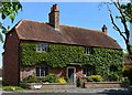
Hazeldene, Childrey, Oxfordshire
Farmhouse, now house. Late C18. Flemish bond brick with dark glazed headers; old tiled roof, brick stacks. 3-unit plan. 2-storey, 3-window range. Segmental arch over 6-panelled C20 door with original bracketed flat hood. Segmental arches (ground floor only) over-original 3-light leaded casements. Dentilled eaves; half-hipped roof; ridge stack. Interior not inspected. Mid C19 wing to rear left in Flemish bond brick; tiled roof; dentilled eaves and lateral stack. Mid C19 iron railing and gate to front.
(Source:Historic England)
Image: © Oswald Bertram
Taken: 4 Jun 2015
0.08 miles
7
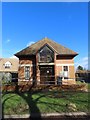
Front of the church
The front of Childrey Methodist church
Image: © Bill Nicholls
Taken: 7 Feb 2019
0.08 miles
8

Chapel Way, Childrey
Chapel Way is a cul-de-sac in Childrey. Ahead is High Street (the B4001).
Image: © Oscar Taylor
Taken: 27 Jun 2023
0.08 miles
9

Hazeldene, Childrey
Hazeldene is an 18th century farmhouse (now just a house) in Childrey on Chapel Way. The building and the railings to the front are Grade II listed, list entry number 1284047 https://historicengland.org.uk/listing/the-list/list-entry/1284047
Image: © Oscar Taylor
Taken: 27 Jun 2023
0.08 miles
10

New Road (B4001), Childrey
New Road (the B4001) in Childrey.
Image: © Oscar Taylor
Taken: 27 Jun 2023
0.08 miles