IMAGES TAKEN NEAR TO
Childrey Way, WANTAGE, OX12 9RX
Introduction
This page details the photographs taken nearby to Childrey Way, OX12 9RX by members of the Geograph project.
The Geograph project started in 2005 with the aim of publishing, organising and preserving representative images for every square kilometre of Great Britain, Ireland and the Isle of Man.

There are currently over 7.5m images from over14,400 individuals and you can help contribute to the project by visiting https://www.geograph.org.uk
Image Map
Images are licensed for reuse under creativecommons.org/licenses/by-sa/2.0
Notes
- Clicking on the map will re-center to the selected point.
- The higher the marker number, the further away the image location is from the centre of the postcode.
Image Listing (29 Images Found)
Images are licensed for reuse under creativecommons.org/licenses/by-sa/2.0
Image
Details
Distance
2
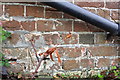
Benchmark on The Goodlake Arms
Ordnance Survey cut mark benchmark described on the Bench Mark Database at http://www.bench-marks.org.uk/bm26769
Image: © Roger Templeman
Taken: 20 Apr 2012
0.06 miles
3
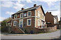
The Goodlake Arms
There is an OS benchmark Image under the drainpipe to the left of the steps
Image: © Roger Templeman
Taken: 20 Apr 2012
0.06 miles

5
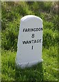
Old Milestone by the A417 in East Challow
Carved stone post by the A417, in parish of East CHALLOWhallow (Vale of White Horse District), Challow Road; East of Goodlake Arms PH, on wide grass bank behind footpath, on South side of road. Faringdon tombstone, erected by the Wallingford, Wantage & Faringdon turnpike trust in the 19th century.
Inscription reads:-
FARINGDON
8
WANTAGE
1
Grade II listed.
List Entry Number: 1048592 https://historicengland.org.uk/listing/the-list/list-entry/1048592
Milestone Society National ID: BE_WAFA01
Image: © A Rosevear
Taken: 28 May 2001
0.12 miles
6
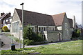
The Old School House
In 1967 the Ordnance Survey levelled a cut mark benchmark (see http://www.bench-marks.org.uk/bm26767 ) on the near corner of the jut on the building which is now a private house.
Image: © Roger Templeman
Taken: 20 Apr 2012
0.13 miles
7
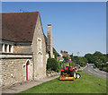
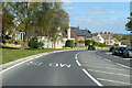
Cutting the Grass, East Challow
Looking down Main Street from outside what looks like the old school.
Image: © Des Blenkinsopp
Taken: 6 Jun 2016
0.13 miles
8
A417 Main Street, East Challow
On the left is the former school, now residential. Grade II listed, 1850s.
Image: © Robin Webster
Taken: 25 Apr 2021
0.14 miles