IMAGES TAKEN NEAR TO
Challow Road, WANTAGE, OX12 9DQ
Introduction
This page details the photographs taken nearby to Challow Road, OX12 9DQ by members of the Geograph project.
The Geograph project started in 2005 with the aim of publishing, organising and preserving representative images for every square kilometre of Great Britain, Ireland and the Isle of Man.

There are currently over 7.5m images from over14,400 individuals and you can help contribute to the project by visiting https://www.geograph.org.uk
Image Map
Images are licensed for reuse under creativecommons.org/licenses/by-sa/2.0
Notes
- Clicking on the map will re-center to the selected point.
- The higher the marker number, the further away the image location is from the centre of the postcode.
Image Listing (118 Images Found)
Images are licensed for reuse under creativecommons.org/licenses/by-sa/2.0
Image
Details
Distance
1
Ham Road, Wantage
From the end of Priory Field
Image: © David Howard
Taken: 27 Mar 2019
0.01 miles
2
Priory Orchard at the junction of Ham Road
Image: © David Howard
Taken: 27 Mar 2019
0.02 miles
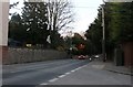
5
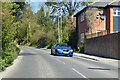
Mill Street, Wantage
Heading away from the town centre towards Faringdon.
Image: © Robin Webster
Taken: 25 Apr 2021
0.07 miles
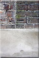
6
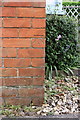
Benchmark on #15 Naldertown
Ordnance Survey cut mark benchmark described on the Bench Mark Database at http://www.bench-marks.org.uk/bm37725
Image: © Roger Templeman
Taken: 26 Apr 2011
0.11 miles
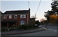
7
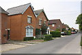
Houses on the south side of Naldertown
Image: © Roger Templeman
Taken: 26 Apr 2011
0.11 miles
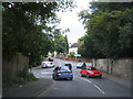
8
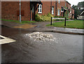
Drain in the Rain
An exceptionally heavy downpour has overloaded the drainage system. There is a small river downhill to the right of this picture and surplus water is making its way there by the quickest route. Number one of a series taken through the car window on a working day in the Environment Agency. See also Image and Image
Image: © Des Blenkinsopp
Taken: 7 Jan 2009
0.11 miles
9
Benchmark on #78 Mill Street
Ordnance Survey cut mark benchmark described on the Bench Mark Database at http://www.bench-marks.org.uk/bm42383
Image: © Roger Templeman
Taken: 30 Apr 2012
0.11 miles
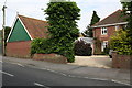
10
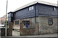
#78 Mill Street
There is an OS benchmark Image on the wall below the window visible through gateway
Image: © Roger Templeman
Taken: 30 Apr 2012
0.11 miles