IMAGES TAKEN NEAR TO
Manor Road, WANTAGE, OX12 8NR
Introduction
This page details the photographs taken nearby to Manor Road, OX12 8NR by members of the Geograph project.
The Geograph project started in 2005 with the aim of publishing, organising and preserving representative images for every square kilometre of Great Britain, Ireland and the Isle of Man.

There are currently over 7.5m images from over14,400 individuals and you can help contribute to the project by visiting https://www.geograph.org.uk
Image Map (Loading...)


Getting Data...Please wait
Leaflet Map data © OpenStreetMap
Images are licensed for reuse under creativecommons.org/licenses/by-sa/2.0
Notes
- Clicking on the map will re-center to the selected point.
- The higher the marker number, the further away the image location is from the centre of the postcode.
Image Listing (6 Images Found)
Images are licensed for reuse under creativecommons.org/licenses/by-sa/2.0
Image
Details
Distance
1
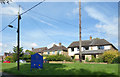
Houses on Manor Road
The southern edge of town by the Welcome to Wantage sign.
Image: © Des Blenkinsopp
Taken: 14 Jun 2017
0.04 miles
2
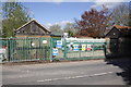
Pumping Station, Manor Road (A338)
Currently construction going on around the site.
Image: © Roger Templeman
Taken: 12 May 2012
0.07 miles
3
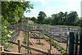
Growing under Nets
Some serious bird proofing here.
Image: © Des Blenkinsopp
Taken: 14 Jun 2017
0.11 miles

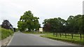
6
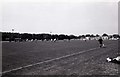
Alfredian Park in Wantage
Alfredian Park is home to Wantage Town.
Image: © Steve Daniels
Taken: 30 Jul 1983
0.24 miles