IMAGES TAKEN NEAR TO
Russell Craggs Lane, WANTAGE, OX12 8GQ
Introduction
This page details the photographs taken nearby to Russell Craggs Lane, OX12 8GQ by members of the Geograph project.
The Geograph project started in 2005 with the aim of publishing, organising and preserving representative images for every square kilometre of Great Britain, Ireland and the Isle of Man.

There are currently over 7.5m images from over14,400 individuals and you can help contribute to the project by visiting https://www.geograph.org.uk
Image Map (Loading...)


Getting Data...Please wait
Leaflet Map data © OpenStreetMap
Images are licensed for reuse under creativecommons.org/licenses/by-sa/2.0
Notes
- Clicking on the map will re-center to the selected point.
- The higher the marker number, the further away the image location is from the centre of the postcode.
Image Listing (40 Images Found)
Images are licensed for reuse under creativecommons.org/licenses/by-sa/2.0
Image
Details
Distance
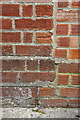
1
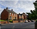
Wantage: Charlton Road
What caught my eye here was the decorative brickwork - characteristic of Wantage and the wider area.
Image: © Stefan Czapski
Taken: 21 Jun 2019
0.09 miles
2
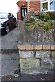
Benchmark on wall in front of #32 Charlton Road
Ordnance Survey cut mark benchmark described on the Bench Mark Database at http://www.bench-marks.org.uk/bm27302
Image: © Roger Templeman
Taken: 3 May 2011
0.09 miles
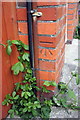
3
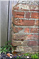
Benchmark on the Drill Hall
Ordnance Survey cut mark benchmark described on the Bench Mark Database at http://www.bench-marks.org.uk/bm27265
Image: © Roger Templeman
Taken: 12 May 2012
0.09 miles
4
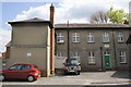
Alma Drill Hall, Springfield Road
There is an OS benchmark Image on the bricks to the right of the wooden gate to Scout Lodge behind the red car.
Image: © Roger Templeman
Taken: 12 May 2012
0.09 miles
5
Benchmark on #31 Springfield Road
Ordnance Survey cut mark benchmark described on the Bench Mark Database at http://www.bench-marks.org.uk/bm27264
Image: © Roger Templeman
Taken: 12 May 2012
0.10 miles
6
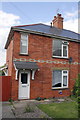
#31 Springfield Road
There is an OS benchmark Image on the side of the house by the wooden gate.
Image: © Roger Templeman
Taken: 12 May 2012
0.10 miles
7
Benchmark on #87 Springfield Road
Ordnance Survey cut mark benchmark described on the Bench Mark Database at http://www.bench-marks.org.uk/bm37005
Image: © Roger Templeman
Taken: 12 May 2012
0.10 miles
8
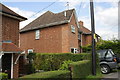
#87 Springfield Road
There is an OS benchmark Image on the side of the house behind the hedge in this image
Image: © Roger Templeman
Taken: 12 May 2012
0.10 miles
9
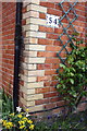
Benchmark on #54 Charlton Road
Ordnance Survey cut mark Benchmark described on the Bench Mark Database at http://www.bench-marks.org.uk/bm27298
Image: © Roger Templeman
Taken: 26 Apr 2011
0.11 miles
10
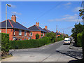
Springfield Road, Wantage
Springfield Road goes to the left and straight on. Larkdown rises to the right.
Image: © Andrew Smith
Taken: 16 Aug 2009
0.12 miles