IMAGES TAKEN NEAR TO
Wallingford Street, WANTAGE, OX12 8BB
Introduction
This page details the photographs taken nearby to Wallingford Street, OX12 8BB by members of the Geograph project.
The Geograph project started in 2005 with the aim of publishing, organising and preserving representative images for every square kilometre of Great Britain, Ireland and the Isle of Man.

There are currently over 7.5m images from over14,400 individuals and you can help contribute to the project by visiting https://www.geograph.org.uk
Image Map
Images are licensed for reuse under creativecommons.org/licenses/by-sa/2.0
Notes
- Clicking on the map will re-center to the selected point.
- The higher the marker number, the further away the image location is from the centre of the postcode.
Image Listing (251 Images Found)
Images are licensed for reuse under creativecommons.org/licenses/by-sa/2.0
Image
Details
Distance
1
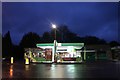
BP garage on Wallingford Street, Wantage
Image: © David Howard
Taken: 27 Oct 2018
0.01 miles
2
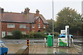
BP garage on Wallingford Street, Wantage
Broadway Motors is part of the garage on the left
Image: © David Howard
Taken: 26 Oct 2019
0.02 miles

4
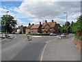
Fork in the road
A fork in the road which takes Wallingford Street to the left and Seesen way to the right.
Image: © Bill Nicholls
Taken: 24 Jul 2010
0.04 miles
5
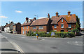
Wallingford Street, Wantage
And, yes, there is a Wantage Road in Wallingford. Two important towns in King Alfred's Saxon Wessex.
Image: © Des Blenkinsopp
Taken: 7 Jul 2018
0.04 miles
6
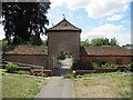
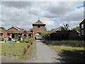
Path through the arch
Footpath leading through an old entrance archway which was part of an old estate. Apart from that I can't tell you any more.
Image: © Bill Nicholls
Taken: 24 Jul 2010
0.06 miles
7
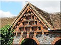
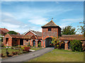
Dovecot in the roof
Small dovecot in the roof of one of the buildings near Stirling close Wantage.
Image: © Bill Nicholls
Taken: 24 Jul 2010
0.06 miles
8
Dovecote by the arch
Image: © Bill Nicholls
Taken: 24 Jul 2010
0.06 miles
9
Footpath to the archway
The footpath leading to the archway that looks to be part of an old farm. Image
Image: © Bill Nicholls
Taken: 24 Jul 2010
0.06 miles
10
Stirlings Stables
All that remains of a large old house called "Stirlings" which was demolished to make way for a small estate of sheltered housing just to the north in the next square.
Image: © Des Blenkinsopp
Taken: 10 Aug 2011
0.06 miles