IMAGES TAKEN NEAR TO
Shannon Close, WANTAGE, OX12 7PT
Introduction
This page details the photographs taken nearby to Shannon Close, OX12 7PT by members of the Geograph project.
The Geograph project started in 2005 with the aim of publishing, organising and preserving representative images for every square kilometre of Great Britain, Ireland and the Isle of Man.

There are currently over 7.5m images from over14,400 individuals and you can help contribute to the project by visiting https://www.geograph.org.uk
Image Map (9 Images)


Getting Data...Please wait
Leaflet Map data © OpenStreetMap
Images are licensed for reuse under creativecommons.org/licenses/by-sa/2.0
Notes
- Clicking on the map will re-center to the selected point.
- The higher the marker number, the further away the image location is from the centre of the postcode.
Image Listing (9 Images Found)
Images are licensed for reuse under creativecommons.org/licenses/by-sa/2.0
Image
Details
Distance
1
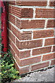
Benchmark on #3 Station Road
Ordnance Survey cut mark benchmark described on the Bench Mark Database at http://www.bench-marks.org.uk/bm28622
Image: © Roger Templeman
Taken: 7 Sep 2011
0.10 miles
2
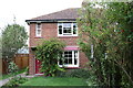
#3 Station Road
There is an OS benchmark Image on the bricks to the left of the door.
Image: © Roger Templeman
Taken: 7 Sep 2011
0.10 miles
3
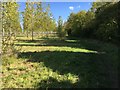
Path to Tulwick Farm
Off the A338 the path to Tulwick Farm
Image: © Shaun Ferguson
Taken: 3 Oct 2017
0.13 miles
4
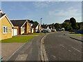
Linden Crescent, Grove
A cul-de-sac off Mayfield Avenue.
Image: © Oscar Taylor
Taken: 9 Oct 2023
0.15 miles
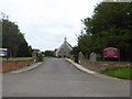
5

St John's Road, Grove
Viewed from the junction with Howard Avenue.
Image: © Andrew Smith
Taken: 17 Apr 2011
0.17 miles
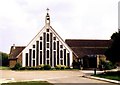

8
Grove Parish Church (St John the Baptist)
Image: © David Smith
Taken: 9 Jun 2018
0.24 miles
9
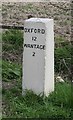
Old Milestone by the A338, north of Grove
Carved stone post by the A338, in parish of Grove (Vale of White Horse District), Station Road, by Tulwick Lane, opposite entrance to Bellinger's Garage, at back of wide well cut grass verge in front of ditch and a sycamore, on East side of road. Vale square, erected by the Besselsleigh turnpike trust in the 19th century.
Inscription reads:-
OXFORD
12
WANTAGE
2
Cancelled carved benchmark on top.
Grade II listed.
List Entry Number: 1368652 https://historicengland.org.uk/listing/the-list/list-entry/1368652
Milestone Society National ID: BE_WABL02
Image: © A Rosevear
Taken: 3 Aug 2004
0.25 miles