IMAGES TAKEN NEAR TO
Sims Gardens, WANTAGE, OX12 7LF
Introduction
This page details the photographs taken nearby to Sims Gardens, OX12 7LF by members of the Geograph project.
The Geograph project started in 2005 with the aim of publishing, organising and preserving representative images for every square kilometre of Great Britain, Ireland and the Isle of Man.

There are currently over 7.5m images from over14,400 individuals and you can help contribute to the project by visiting https://www.geograph.org.uk
Image Map (Loading...)


Getting Data...Please wait
Leaflet Map data © OpenStreetMap
Images are licensed for reuse under creativecommons.org/licenses/by-sa/2.0
Notes
- Clicking on the map will re-center to the selected point.
- The higher the marker number, the further away the image location is from the centre of the postcode.
Image Listing (28 Images Found)
Images are licensed for reuse under creativecommons.org/licenses/by-sa/2.0
Image
Details
Distance
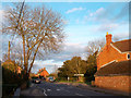
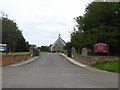
3
The Old Post Office in Denchworth Road
Image: © Steve Daniels
Taken: 15 Mar 2010
0.06 miles
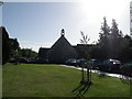
5
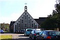
Grove Parish Church (St John the Baptist)
Image: © David Smith
Taken: 9 Jun 2018
0.07 miles
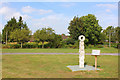
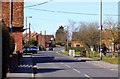
6
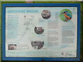
Information Board at Letcombe Brook, Grove
This information board is on the west side of Letcombe Brook in Denchworth Road. It has the
following wording and images:
Title: LETCOMBE BROOK
Left column
Welcome to the Letcombe Brook (Map is on the right)
The brook is a chalk stream and these are globally rare. It flows for 12kms (7½ miles) until it
joins the Childrey Brook. This meets the River Ock, which runs into the River Thames.
Rain falls on to the chalk hills above the Letcombes. The chalk acts like a sponge soaking up
water until it emerges from the ground as springs. Regular winter rainfall is needed to
recharge the aquifer and keep the brook flowing throughout the year.
Letcombe Brook Project
The project aims to enhance and protect the natural beauty of the brook and to help people
appreciate the environment.
Image: Local people clear rubbish from the brook.
Middle column
Bullhead image
A fish also known as Miller's Thumb. It hides under stones feeding on freshwater shrimps and
insects.
Image: Grove Middle Mill
Image: Cattle drinking at Village Green, 1910
Wildlife on the brink
The effects of development, intensive agriculture and increased demand for water has resulted
in degraded habitats. Yet despite these issues the brook still supports a rich diversity of
wildlife. It is cleaner and less polluted now than it has been for many years.
Industrial history
Diverse and prosperous industries grew up around the brook, which was the main source of
water and power.
Mills
In 1086 there were 10 mills recorded on the brook. Many mills ground corn, others were
adapted for cloth making, silk spinning and rope making using hemp.
Tanning
Large quantities of water were used to process leather. For centuries tanning brought wealth
to the area and the last tannery in Wantage closed in 1825.
Right column
Kingfisher image
An expert angler, with a diet of small fish such as sticklebacks as well as insects. Numbers have
declined in recent years.
What you can do to help
• Take your litter home and clear up dog mess
• Please don't feed the ducks
Many people enjoy feeding ducks, but this is harmful to them and the environment. Feeding
waterfowl causes:
• Poor nutrition and spread of disease
• Overcrowding and unnatural behaviour
• Pollution and environmental damage
• Attracts rats
• Save water
To make sure there is enough water for both us and wildlife in future years, use water wisely.
Contact Thames Water on 0845 9200 800 for free leaflets on saving water or check out the
website www.thames-water.co.uk/waterwise.
To find out more about the brook, visit the other boards at Mably Way and Mary Green in
Grove.
Foot of the information board
Letcombe - lede in the combe - river in the valley
Wantage - intermittent stream
Grove - thicket on copse
Logos: Grove Parish Council
Grove Joint Environmental Trust
Vale of White Horse District Council
Environment Agency
CONTACTS: Environment Agency is responsible for protecting and improving rivers. For
pollution and flood defence matters call 24-hour emergency hotline 0800 80 70 60.
Public open spaces: Grove Parish Council - 01235 766599 and Vale of White Horse
District Council - 01235 520202
Image: © David Hillas
Taken: 4 May 2023
0.08 miles