IMAGES TAKEN NEAR TO
Cherry Croft, WANTAGE, OX12 7GF
Introduction
This page details the photographs taken nearby to Cherry Croft, OX12 7GF by members of the Geograph project.
The Geograph project started in 2005 with the aim of publishing, organising and preserving representative images for every square kilometre of Great Britain, Ireland and the Isle of Man.

There are currently over 7.5m images from over14,400 individuals and you can help contribute to the project by visiting https://www.geograph.org.uk
Image Map
Images are licensed for reuse under creativecommons.org/licenses/by-sa/2.0
Notes
- Clicking on the map will re-center to the selected point.
- The higher the marker number, the further away the image location is from the centre of the postcode.
Image Listing (15 Images Found)
Images are licensed for reuse under creativecommons.org/licenses/by-sa/2.0
Image
Details
Distance
1
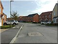
Cherrycroft, Wantage
Part of the Kingsgrove housing estate.
Image: © Oscar Taylor
Taken: 9 Oct 2023
0.04 miles
2
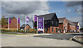
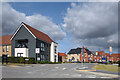
Welcome to Downland
More of the large new housing development to the east of Wantage.
Image: © Des Blenkinsopp
Taken: 11 Sep 2021
0.07 miles
3
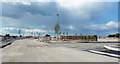
Building Site east of Wantage
Half of South Oxfordshire is a building site now. All part of the government's plan to make Swindon part of West London.
At least they've planted some trees, and a useful hedge.
Image: © Des Blenkinsopp
Taken: 4 May 2019
0.07 miles
4
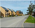
Elder Way, Wantage
Part of the Kingsgrove housing estate.
Image: © Oscar Taylor
Taken: 9 Oct 2023
0.08 miles
5
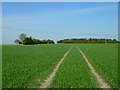
Farmland, Wantage
Arable land and a copse viewed from a footpath to the east of Charlton.
Image: © Andrew Smith
Taken: 9 Apr 2011
0.08 miles
6
Appletons, off Elder Way
The same place as my picture Image from two years ago.
Quite a difference. The streets have names and there are people living here.
And the useful hedge is still there.
Image: © Des Blenkinsopp
Taken: 11 Sep 2021
0.09 miles
7
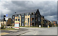
Corner of Primrose Avenue
Part of a large new housing development to the east of Wantage.
What the board on the corner refers to as "A new community nestled within rolling countryside."
Well....whatever....
Image: © Des Blenkinsopp
Taken: 11 Sep 2021
0.09 miles
9
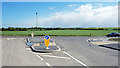
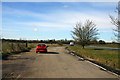
A New Road Junction
Access to new houses being built in the field behind me. Image
Image: © Des Blenkinsopp
Taken: 4 May 2019
0.13 miles
10
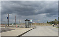
New Bus Terminus, Kingsgrove
Where one day soon people will wait for the bus.
Just now it's the buses that are waiting for the people. The shelter and turnaround have been completed but there aren't any houses yet.
Image: © Des Blenkinsopp
Taken: 11 Sep 2021
0.17 miles