IMAGES TAKEN NEAR TO
Grove Road, WANTAGE, OX12 7BT
Introduction
This page details the photographs taken nearby to Grove Road, OX12 7BT by members of the Geograph project.
The Geograph project started in 2005 with the aim of publishing, organising and preserving representative images for every square kilometre of Great Britain, Ireland and the Isle of Man.

There are currently over 7.5m images from over14,400 individuals and you can help contribute to the project by visiting https://www.geograph.org.uk
Image Map (57 Images)


Getting Data...Please wait
Leaflet Map data © OpenStreetMap
Images are licensed for reuse under creativecommons.org/licenses/by-sa/2.0
Notes
- Clicking on the map will re-center to the selected point.
- The higher the marker number, the further away the image location is from the centre of the postcode.
Image Listing (57 Images Found)
Images are licensed for reuse under creativecommons.org/licenses/by-sa/2.0
Image
Details
Distance
1
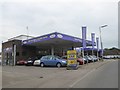
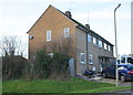
Car wash and motor sales, Grove Road, Wantage
The layout suggests that this was formerly a filling station
Image: © David Smith
Taken: 9 Jun 2018
0.01 miles
3
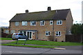
#2 Courtenay Road
There is an Ordnance Survey cut mark benchmark http://www.bench-marks.org.uk/bm27284 on the near corner of the house behind the wooden fence
Image: © Roger Templeman
Taken: 28 Dec 2013
0.11 miles
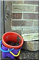
5
Semi-detached houses on Courtenay Road
There is an OS benchmark Image on the near corner of the house, above the small plastic buckets
Image: © Roger Templeman
Taken: 28 Dec 2013
0.13 miles
8
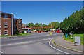
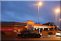
Junction of Grove Street (A338) and Humber Close, Wantage
In the foreground is Humber Close, leading onto Grove Street, which here forms part of the A338 road. Behind the roundabout in the distance is a filling station operated by Sainsbury's. Their supermarket is nearby, although not visible in this photograph.
Image: © P L Chadwick
Taken: 23 Jul 2012
0.13 miles
10
Benchmark on #20 Courtenay Road
Ordnance Survey cut mark benchmark described on the Bench Mark Database at http://www.bench-marks.org.uk/bm27285
Image: © Roger Templeman
Taken: 28 Dec 2013
0.13 miles