IMAGES TAKEN NEAR TO
Haywards Close, WANTAGE, OX12 7AT
Introduction
This page details the photographs taken nearby to Haywards Close, OX12 7AT by members of the Geograph project.
The Geograph project started in 2005 with the aim of publishing, organising and preserving representative images for every square kilometre of Great Britain, Ireland and the Isle of Man.

There are currently over 7.5m images from over14,400 individuals and you can help contribute to the project by visiting https://www.geograph.org.uk
Image Map
Images are licensed for reuse under creativecommons.org/licenses/by-sa/2.0
Notes
- Clicking on the map will re-center to the selected point.
- The higher the marker number, the further away the image location is from the centre of the postcode.
Image Listing (94 Images Found)
Images are licensed for reuse under creativecommons.org/licenses/by-sa/2.0
Image
Details
Distance
1
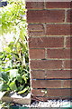
Benchmark on the side of #28 Garston Lane
Ordnance Survey cut mark benchmark described on the Bench Mark Database at http://www.bench-marks.org.uk/bm27278
Image: © Roger Templeman
Taken: 3 May 2011
0.04 miles
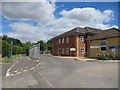
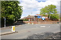
2
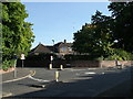
Wantage Hospital
Viewed from the south.In SW corner of grid square
Image: © Alec Samler
Taken: 24 Sep 2004
0.04 miles
3
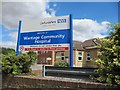
Hospital sign
The NHS sign telling you that it is Wantage community hospital
Image: © Bill Nicholls
Taken: 24 Jul 2010
0.04 miles
4

Morgan on Garston lane
Rather nice Morgan sports car parked up along Garston Lane, Wantage.
Image: © Bill Nicholls
Taken: 24 Jul 2010
0.05 miles
5
Footpath beside the hospital
View of some new pensioners housing which is behind Wantage Hospital
Image: © Bill Nicholls
Taken: 24 Jul 2010
0.06 miles
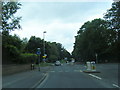
6
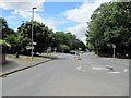
Mini-roundabouts on Wallingford Street
View along Wallingford Street and the two mini-roundabouts.
Image: © Bill Nicholls
Taken: 24 Jul 2010
0.06 miles
7
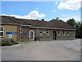
Hospital car park
Part of Wantage cottage hospital that has now expanded to being a well used local hospital not that the NHS have not tried to shut it.
Image: © Bill Nicholls
Taken: 24 Jul 2010
0.06 miles
8
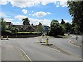
Roundabout on Wallingford Street
This used to be a crossroads once but they moved the entrance to Ormond Road which is over to the right. There also used to be a small Hansel and Gretel house opposite but it was demolished and the one you see here built. All that is left of the original entrance to Ormond road is on the opposite side of the road.
Image: © Bill Nicholls
Taken: 24 Jul 2010
0.06 miles
9
Wantage Community Hospital at road junction
The junction is Garston Lane off Charlton Road. The wall in front of the hospital appears to have been replaced since 1973 when the Ordnance Survey cut a benchmark on it (see http://www.bench-marks.org.uk/bm27277 )
Image: © Roger Templeman
Taken: 30 Apr 2012
0.07 miles