IMAGES TAKEN NEAR TO
Peregrine Way, WANTAGE, OX12 0QB
Introduction
This page details the photographs taken nearby to Peregrine Way, OX12 0QB by members of the Geograph project.
The Geograph project started in 2005 with the aim of publishing, organising and preserving representative images for every square kilometre of Great Britain, Ireland and the Isle of Man.

There are currently over 7.5m images from over14,400 individuals and you can help contribute to the project by visiting https://www.geograph.org.uk
Image Map (5 Images)


Getting Data...Please wait
Leaflet Map data © OpenStreetMap
Images are licensed for reuse under creativecommons.org/licenses/by-sa/2.0
Notes
- Clicking on the map will re-center to the selected point.
- The higher the marker number, the further away the image location is from the centre of the postcode.
Image Listing (5 Images Found)
Images are licensed for reuse under creativecommons.org/licenses/by-sa/2.0
Image
Details
Distance
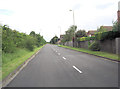
2
Houses, Grove
Looking along one of the housing estate's many interconnecting alleyways. This one is at the end of Collett Way.
Image: © Andrew Smith
Taken: 17 Apr 2011
0.08 miles
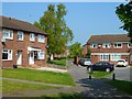
3

Junction of Mallard Way with Newlands Drive, Grove
Image: © David Smith
Taken: 9 Jun 2018
0.11 miles
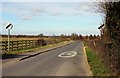
4
Newlands Drive approaches junction with Teal Close
This is a familiar picture in Oxfordshire. A town planner draws a line on the map, across some green fields. The line will become a relief-road or a by-pass around an old settlement but inside the line the map is coloured in with a new housing estate.
Image: © Stuart Logan
Taken: 15 Jul 2012
0.13 miles