IMAGES TAKEN NEAR TO
Monks Close, WANTAGE, OX12 0LS
Introduction
This page details the photographs taken nearby to Monks Close, OX12 0LS by members of the Geograph project.
The Geograph project started in 2005 with the aim of publishing, organising and preserving representative images for every square kilometre of Great Britain, Ireland and the Isle of Man.

There are currently over 7.5m images from over14,400 individuals and you can help contribute to the project by visiting https://www.geograph.org.uk
Image Map
Images are licensed for reuse under creativecommons.org/licenses/by-sa/2.0
Notes
- Clicking on the map will re-center to the selected point.
- The higher the marker number, the further away the image location is from the centre of the postcode.
Image Listing (165 Images Found)
Images are licensed for reuse under creativecommons.org/licenses/by-sa/2.0
Image
Details
Distance
2
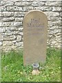
West Hanney Churchyard
Gravestone commemorating Paul Mackarel in West Hanney Churchyard
Image: © John Firth
Taken: Unknown
0.03 miles
5
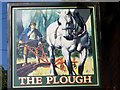
Sign for the Plough, West Hanney
The Plough is one of the commonest pub names in the country having been in regular use since at least the 16th century.
Image: © Maigheach-gheal
Taken: 14 Apr 2008
0.05 miles
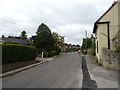
6
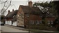
Church Street, West Hanney
A cottage end-on to the road backs on to the Plough pub.
Image: © Chris Brown
Taken: 19 Feb 2017
0.06 miles
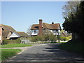
7
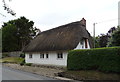
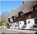
Thatched cottage on Main Street, West Hanney
Image: © JThomas
Taken: 15 Jul 2019
0.07 miles
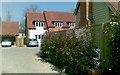
8
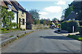
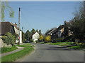
Main Street, West Hanney
The high kerb suggests that the road is sometimes flooded.
Image: © Robin Webster
Taken: 25 Apr 2021
0.07 miles