IMAGES TAKEN NEAR TO
School Road, WANTAGE, OX12 0LA
Introduction
This page details the photographs taken nearby to School Road, OX12 0LA by members of the Geograph project.
The Geograph project started in 2005 with the aim of publishing, organising and preserving representative images for every square kilometre of Great Britain, Ireland and the Isle of Man.

There are currently over 7.5m images from over14,400 individuals and you can help contribute to the project by visiting https://www.geograph.org.uk
Image Map
Images are licensed for reuse under creativecommons.org/licenses/by-sa/2.0
Notes
- Clicking on the map will re-center to the selected point.
- The higher the marker number, the further away the image location is from the centre of the postcode.
Image Listing (166 Images Found)
Images are licensed for reuse under creativecommons.org/licenses/by-sa/2.0
Image
Details
Distance
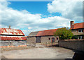
1
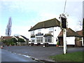
The Lamb Inn
A 1930's built village local.
Image: © Jonathan Billinger
Taken: 10 Jan 2007
0.02 miles
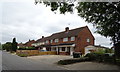
2
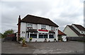
Indian Restaurant, West Hanney
The former Lamb Inn on School Road - Image
Image: © JThomas
Taken: 15 Jul 2019
0.04 miles
3
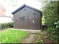
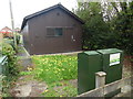
West Hanney Telephone Exchange (1)
Situated in Winter Lane, this TE comprises of a dark wooden building common in rural areas. It has the code SMWHY and provides telephone and broadband services to 753 residential and 40 non-residential premises in West Hanney plus Charney Bassett, Denchworth, East Hanney and Lyford nearby.
Image: © David Hillas
Taken: 26 Apr 2019
0.09 miles
4
West Hanney Telephone Exchange (2)
Taken in Winter Lane, this photo shows the TE with a BT telecoms cabinet in front of it. A label on the cabinet mentions that Fibre Broadband is now available at this TE. Another BT telecoms cabinet can just be seen to the left of the photo. The numbering ranges of this TE are (01235) 867xxx, 868xxx, the (01235) referring to the Abingdon group of eight TEs, and its postcode is OX12 0LF.
Image: © David Hillas
Taken: 26 Apr 2019
0.09 miles
7
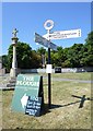
Old Direction Sign - Signpost on West Hanney village green
Annulus finial - 4 arms; Oxfordshire CC halo new post by the UC road, in parish of West Hanney (Vale Of White Horse District), on the village green, by the cross: OXVW_WES Image
Surveyed
Milestone Society National ID: BE_SU4092
Image: © Alan Rosevear
Taken: 19 Jul 2013
0.11 miles
8
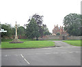
Winter Lane terminates at The Green
The Butter Cross on The Green is in the foreground, whilst West Hanney House lies behind the trees.
Image: © Stuart Logan
Taken: 15 Jul 2012
0.11 miles
9
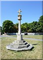
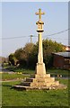
Old Central Cross on The Green, West Hanney Parish
West Hanney Cross, old base and steps in a new cross, by the UC road, in parish of West Hanney (Vale Of White Horse District), on The Green at cross roads, on grassed area between Church Street and School Road, close to finger post: BE_SU4092 Image
Grade II listed.
List Entry Number: 1368682 https://historicengland.org.uk/listing/the-list/list-entry/1368682
Surveyed
Milestone Society National ID: OXVW_WES.
Image: © Alan Rosevear
Taken: 19 Jul 2013
0.11 miles