IMAGES TAKEN NEAR TO
Vickers Way, OX12 0GZ
Introduction
This page details the photographs taken nearby to Vickers Way, OX12 0GZ by members of the Geograph project.
The Geograph project started in 2005 with the aim of publishing, organising and preserving representative images for every square kilometre of Great Britain, Ireland and the Isle of Man.

There are currently over 7.5m images from over14,400 individuals and you can help contribute to the project by visiting https://www.geograph.org.uk
Image Map (Loading...)


Getting Data...Please wait
Leaflet Map data © OpenStreetMap
Images are licensed for reuse under creativecommons.org/licenses/by-sa/2.0
Notes
- Clicking on the map will re-center to the selected point.
- The higher the marker number, the further away the image location is from the centre of the postcode.
Image Listing (5 Images Found)
Images are licensed for reuse under creativecommons.org/licenses/by-sa/2.0
Image
Details
Distance
1
Wellington Gate, Grove
A housing estate.
Image: © Oscar Taylor
Taken: 9 Oct 2023
0.06 miles
2

Lancaster Crescent roundabout
A very fancy roundabout with block paving and nice planting in the Wellington Gate estate. Could use a bench?
Image: © Oscar Taylor
Taken: 9 Oct 2023
0.09 miles
3

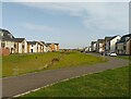
Field near Wellington Gate
Looking towards Grove Technology Park from Wellington Gate. There is a field between the two at the moment.
Image: © Oscar Taylor
Taken: 9 Oct 2023
0.18 miles
4
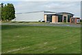
Grove Technology Park
The park has expanded rapidly in recent years. This building went up in 2007 and is the home of CMS who are suppliers of office furniture components. It is the first building to be erected to the east of the former airfield perimeter road, ie within the runway area.
Image: © Graham Horn
Taken: 22 Jul 2008
0.21 miles
5
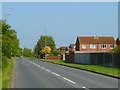
Newlands Drive, Grove
Approaching the junction of Columbia Way on the edge of the housing estate.
Image: © Andrew Smith
Taken: 17 Apr 2011
0.21 miles