IMAGES TAKEN NEAR TO
Pullen Field, WANTAGE, OX12 0GJ
Introduction
This page details the photographs taken nearby to Pullen Field, OX12 0GJ by members of the Geograph project.
The Geograph project started in 2005 with the aim of publishing, organising and preserving representative images for every square kilometre of Great Britain, Ireland and the Isle of Man.

There are currently over 7.5m images from over14,400 individuals and you can help contribute to the project by visiting https://www.geograph.org.uk
Image Map (Loading...)


Getting Data...Please wait
Leaflet Map data © OpenStreetMap
Images are licensed for reuse under creativecommons.org/licenses/by-sa/2.0
Notes
- Clicking on the map will re-center to the selected point.
- The higher the marker number, the further away the image location is from the centre of the postcode.
Image Listing (42 Images Found)
Images are licensed for reuse under creativecommons.org/licenses/by-sa/2.0
Image
Details
Distance
6
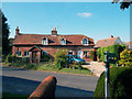
Cottages, East Hanney
From the brick and tile work and roof line, this looks like an old central part with later extensions at both ends.
Image: © Des Blenkinsopp
Taken: 14 Oct 2011
0.09 miles
7
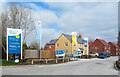
The Silk Mill, East Hanney
A new development off Summertown on the southern edge of the village.
The nearby Dandridge's Mill on the Letcombe Brook was built as a silk mill in 1820.
Image: © Des Blenkinsopp
Taken: 2 Apr 2021
0.10 miles
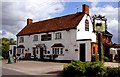
10
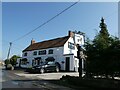
The Black Horse, East Hanney: late March 2022
Image: © Basher Eyre
Taken: 26 Mar 2022
0.12 miles