IMAGES TAKEN NEAR TO
Lyford, WANTAGE, OX12 0EF
Introduction
This page details the photographs taken nearby to OX12 0EF by members of the Geograph project.
The Geograph project started in 2005 with the aim of publishing, organising and preserving representative images for every square kilometre of Great Britain, Ireland and the Isle of Man.

There are currently over 7.5m images from over14,400 individuals and you can help contribute to the project by visiting https://www.geograph.org.uk
Image Map
Images are licensed for reuse under creativecommons.org/licenses/by-sa/2.0
Notes
- Clicking on the map will re-center to the selected point.
- The higher the marker number, the further away the image location is from the centre of the postcode.
Image Listing (94 Images Found)
Images are licensed for reuse under creativecommons.org/licenses/by-sa/2.0
Image
Details
Distance
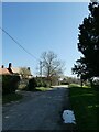
1
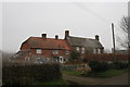
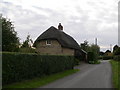
Lyford Almshouses
Nearly missed these Almshouses at Lyford
Image: © Bill Nicholls
Taken: 22 Apr 2018
0.00 miles
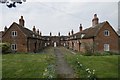
2
Almshouse courtyard
The courtyard at the Lyford almshouses
Image: © Bill Nicholls
Taken: 22 Apr 2018
0.01 miles
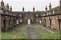
3
Almshouse wing
One wing of the almshouses at Lyford
Image: © Bill Nicholls
Taken: 22 Apr 2018
0.01 miles
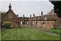
4
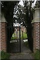
Gate to the almshouse
Wrought iron gate leading to the almshouses at Lyford
Image: © Bill Nicholls
Taken: 22 Apr 2018
0.02 miles
5
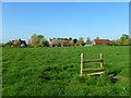
Pasture, Lyford
A stile without a fence marks the line of a public footpath.
Image: © Andrew Smith
Taken: 10 Apr 2011
0.06 miles